IMAGES TAKEN NEAR TO
North Road, DURHAM, DH1 4RR
Introduction
This page details the photographs taken nearby to North Road, DH1 4RR by members of the Geograph project.
The Geograph project started in 2005 with the aim of publishing, organising and preserving representative images for every square kilometre of Great Britain, Ireland and the Isle of Man.

There are currently over 7.5m images from over14,400 individuals and you can help contribute to the project by visiting https://www.geograph.org.uk
Image Map (Loading...)


Getting Data...Please wait
Leaflet Map data © OpenStreetMap
Images are licensed for reuse under creativecommons.org/licenses/by-sa/2.0
Notes
- Clicking on the map will re-center to the selected point.
- The higher the marker number, the further away the image location is from the centre of the postcode.
Image Listing (212 Images Found)
Images are licensed for reuse under creativecommons.org/licenses/by-sa/2.0
Image
Details
Distance
3
Ordnance Survey Cut Mark
This OS cut mark can be found on The Grey Tower, North Road. It marks a point 70.616m above mean sea level.
Image: © Adrian Dust
Taken: 14 Sep 2018
0.01 miles
4
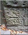
Old Boundary Marker on North Road, Durham
Municipal Boundary Marker on the pavement and with its south-west face against a stone boundary wall on the west side of North Road 40 metres north of Obelisk Lane. Durham parish. Inscribed D.U. / S.A (Durham Urban Sanitary Authority) and D &C L S / H B (Durham and Chester le Street Highway Board) on its adjacent faces and H&LA / 1878 (Highways & Locomotive Act 1878) on its bevelled top face. It marked the road maintenance responsibility boundary between the Durham Urban Sanitary Authority and the Durham & Chester-le-Street Highway Board, although the city boundary ran up the centre of the road for most of the length of North Road. Grade II Listed details https://historicengland.org.uk/listing/the-list/list-entry/1160415. See also http://www.geograph.org.uk/photo/6126508.
Milestone Society National ID: DU_DUR02pb
Image: © D Butler
Taken: 26 Nov 2017
0.02 miles
5
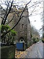
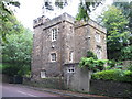
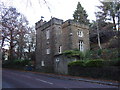
The Grey Tower
On North Road, Durham. Believed to be early C19, but may be late C18. It's not a part of an old castle, despite its appearance, but has always been a private residence.
Image: © Robert Graham
Taken: 17 Nov 2014
0.02 miles
6
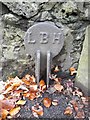
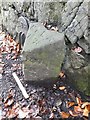
Old Boundary Marker by North Road, Durham
Municipal Boundary Marker by the UC road, in parish of Durham (Durham District), North Road approx. 37m North of Obelisk Lane, and opposite the garage entrance for the Grey Tower, on the pavement and with its South-west face against the stone boundary wall. Next to Boundary stone: DU_DUR02pb Image
Inscription reads:-
LBH
Surveyed
Milestone Society National ID: DU_DUR03pb
Image: © Milestone Society
Taken: Unknown
0.02 miles
7
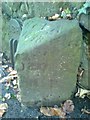
Old Boundary Marker on North Road, Durham
Municipal Boundary Marker on the pavement and with its south-west face against a stone boundary wall on the west side of North Road 40 metres north of Obelisk Lane. Durham parish. Inscribed D.U. / S.A (Durham Urban Sanitary Authority) and D &C L S / H B (Durham and Chester le Street Highway Board) on its adjacent faces and H&LA / 1878 (Highways & Locomotive Act 1878) on its bevelled top face. It marked the road maintenance responsibility boundary between the Durham Urban Sanitary Authority and the Durham & Chester-le-Street Highway Board, although the city boundary ran up the centre of the road for most of the length of North Road.
See also: Image
Grade II listed.
List Entry Number: 1160415 https://historicengland.org.uk/listing/the-list/list-entry/1160415.
Milestone Society National ID: DU_DUR02pb
Image: © D Garside
Taken: 15 Dec 2014
0.02 miles
8
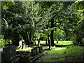
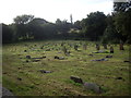
Gravestones at St. Cuthbert's Church Graveyard
The Graveyard of the Anglican Church of St. Cuthbert, north of the city centre and adjacent to Wharton Park.
Here, a short, grassy path leads past tree-shadowed graves to further gravestones in a more open area of the graveyard.
Image: © Trevor Littlewood
Taken: 23 Aug 2021
0.05 miles
9
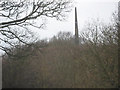
Obelisk in North Road Durham City
Seen from Wharton Park built in 1840 a marker point for Durham University's Observatory which lies a mile to the south near Durham School.
Image: © Peter Robinson
Taken: 27 Feb 2011
0.05 miles
10
Churchyard of St Cuthbert's Church
Undergoing some autumn TLC.
Image: © Stanley Howe
Taken: 21 Sep 2013
0.05 miles