IMAGES TAKEN NEAR TO
Parkside, DURHAM, DH1 4RE
Introduction
This page details the photographs taken nearby to Parkside, DH1 4RE by members of the Geograph project.
The Geograph project started in 2005 with the aim of publishing, organising and preserving representative images for every square kilometre of Great Britain, Ireland and the Isle of Man.

There are currently over 7.5m images from over14,400 individuals and you can help contribute to the project by visiting https://www.geograph.org.uk
Image Map
Images are licensed for reuse under creativecommons.org/licenses/by-sa/2.0
Notes
- Clicking on the map will re-center to the selected point.
- The higher the marker number, the further away the image location is from the centre of the postcode.
Image Listing (318 Images Found)
Images are licensed for reuse under creativecommons.org/licenses/by-sa/2.0
Image
Details
Distance
3
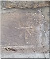
Ordnance Survey Cut Mark
This OS cut mark can be found on a wall NE side of North Road. It marks a point 55.144m above mean sea level.
Image: © Adrian Dust
Taken: 14 Sep 2018
0.02 miles
4
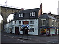
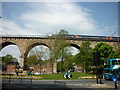
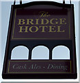
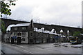
The Bridge Hotel, Durham
With the viaduct behind.
Image: © JThomas
Taken: 17 Nov 2012
0.02 miles
7
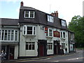
The Bridge Hotel, North Road, Durham
Taken during the 2019 Lumiere light festival
Image: © Richard Cooke
Taken: 16 Nov 2019
0.02 miles
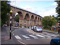
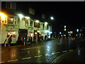
9
Bus and train passing the Bridge Hotel, Durham
Viewed on a very grey day.
Image: © Bill Boaden
Taken: 24 May 2013
0.03 miles