IMAGES TAKEN NEAR TO
Pimlico, DURHAM, DH1 4QW
Introduction
This page details the photographs taken nearby to Pimlico, DH1 4QW by members of the Geograph project.
The Geograph project started in 2005 with the aim of publishing, organising and preserving representative images for every square kilometre of Great Britain, Ireland and the Isle of Man.

There are currently over 7.5m images from over14,400 individuals and you can help contribute to the project by visiting https://www.geograph.org.uk
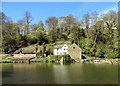
Image Map
Images are licensed for reuse under creativecommons.org/licenses/by-sa/2.0
Notes
- Clicking on the map will re-center to the selected point.
- The higher the marker number, the further away the image location is from the centre of the postcode.
Image Listing (653 Images Found)
Images are licensed for reuse under creativecommons.org/licenses/by-sa/2.0
Image
Details
Distance
1
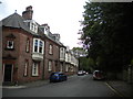
Grove Street, Durham (2)
Seen from South Street.
Image: © Richard Vince
Taken: 19 Jun 2019
0.01 miles
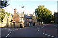
2
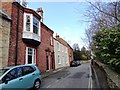
Pimlico, Durham City
This little street runs down from the bottom end of South Street, which runs along the top of the river bank opposite the cathedral.
Image: © Robert Graham
Taken: 15 Apr 2013
0.03 miles
4
Grove Street, Durham (1)
Seen from the end of Margery Lane.
Image: © Richard Vince
Taken: 19 Jun 2019
0.04 miles
5
Junction of Grove Street
Margery Lane meets Grove Street.
Image: © DS Pugh
Taken: 28 Aug 2014
0.04 miles
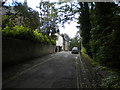
6
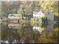
Mill House
A sunny still day on Durham river bank.
Image: © Andrew Greiff
Taken: 6 Nov 2003
0.05 miles
7
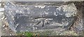
Ordnance Survey Cut Mark
This OS cut mark can be found on the angle post of Rectory Garden. It marks a point 68.086m above mean sea level.
Image: © Adrian Dust
Taken: 15 Sep 2018
0.05 miles
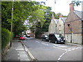
8
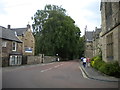
North end of Quarryheads Lane, Durham
Seen from Margery Lane. Durham School is on the right.
Image: © Richard Vince
Taken: 19 Jun 2019
0.05 miles
9
Former corn mill at Durham City
This is on the western banks of the River Wear upstream from the Framwellgate Bridge.
Image: © Robert Graham
Taken: 27 Apr 2015
0.06 miles
10
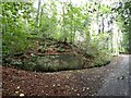
Durham - Pathway climbing the bank near Pimlico
This track leads up from the river walk path up to the junction of Pimlico, South Street and Grove Street. The wall ahead which seems to be some kind of retaining wall has a plaque set into it, but I don't know what it says, if anything.
Image: © Rob Farrow
Taken: 12 Sep 2022
0.06 miles