IMAGES TAKEN NEAR TO
South Street, DURHAM, DH1 4QP
Introduction
This page details the photographs taken nearby to South Street, DH1 4QP by members of the Geograph project.
The Geograph project started in 2005 with the aim of publishing, organising and preserving representative images for every square kilometre of Great Britain, Ireland and the Isle of Man.

There are currently over 7.5m images from over14,400 individuals and you can help contribute to the project by visiting https://www.geograph.org.uk
Image Map
Images are licensed for reuse under creativecommons.org/licenses/by-sa/2.0
Notes
- Clicking on the map will re-center to the selected point.
- The higher the marker number, the further away the image location is from the centre of the postcode.
Image Listing (1095 Images Found)
Images are licensed for reuse under creativecommons.org/licenses/by-sa/2.0
Image
Details
Distance
1
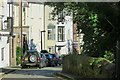
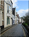
South Street, Durham
The large townhouses in this exclusive street have views across the river to the cathedral.
Image: © David Robinson
Taken: 28 Sep 2017
0.01 miles
2
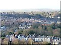
South Street, Durham
Seen from the top of the central tower of Durham Cathedral.
Image: © Christine Johnstone
Taken: 7 Feb 2012
0.01 miles
3
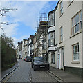
Durham: up South Street
Attractive houses high above the River Wear, opposite the Cathedral.
Image: © John Sutton
Taken: 11 May 2015
0.01 miles
4
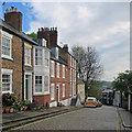
South Street, Durham city
Looking north up this street of late 18th and 19th century houses, many of which are listed buildings. The street runs along the top of the river banks opposite the cathedral and gives lovely views of this ancient structure.
Image: © Robert Graham
Taken: 15 Apr 2013
0.02 miles
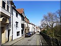
5
Durham: South Street
Attractive houses high above the River Wear, opposite the Cathedral.
Image: © John Sutton
Taken: 11 May 2015
0.03 miles
6
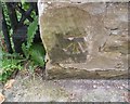
Ordnance Survey Cut Mark
This OS cut mark can be found on the wall east side of South Street. It marks a point 66.349m above mean sea level.
Image: © Adrian Dust
Taken: 15 Sep 2018
0.04 miles
7
Durham: the north end of South Street
Looking down the hill towards Crossgate, North Road and Framwelgate Bridge.
Image: © John Sutton
Taken: 11 May 2015
0.04 miles
8
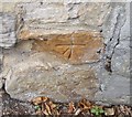
Ordnance Survey Cut Mark
This OS cut mark can be found on No57 South Street. It marks a point 187.2ft above mean sea level.
Image: © Adrian Dust
Taken: 15 Sep 2018
0.04 miles
9
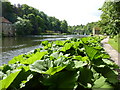
Riverside Walk by the Wear
Gunnera in the foreground, the Old Prebends Mill to the left and Prebends Bridge in the distance.
Image: © pam fray
Taken: 2 Jul 2010
0.05 miles
10
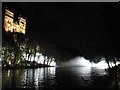
"Fogscape#03238" below Durham Cathedral, Durham Lumiere
Image: © Les Hull
Taken: 15 Nov 2019
0.06 miles