IMAGES TAKEN NEAR TO
Ellam Avenue, DURHAM, DH1 4PG
Introduction
This page details the photographs taken nearby to Ellam Avenue, DH1 4PG by members of the Geograph project.
The Geograph project started in 2005 with the aim of publishing, organising and preserving representative images for every square kilometre of Great Britain, Ireland and the Isle of Man.

There are currently over 7.5m images from over14,400 individuals and you can help contribute to the project by visiting https://www.geograph.org.uk
Image Map
Images are licensed for reuse under creativecommons.org/licenses/by-sa/2.0
Notes
- Clicking on the map will re-center to the selected point.
- The higher the marker number, the further away the image location is from the centre of the postcode.
Image Listing (27 Images Found)
Images are licensed for reuse under creativecommons.org/licenses/by-sa/2.0
Image
Details
Distance
1
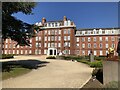
Ustinov College, Durham
Ustinov is exclusively for post-graduate students and is Durham University's largest college. The building was originally built for Neville's Cross College in the 1920s, becoming New College Durham upon merging with Durham Technical College in 1977 and ceasing to be part of the university. New College Durham re-developed their Framwellgate site and moved out in 2004. Ustinov College re-located to the current site in 2017.
Image: © David Robinson
Taken: 27 Mar 2022
0.05 miles
2
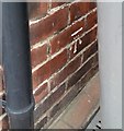
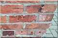
Ordnance Survey Cut Mark
This OS cut mark can be found on No9 Darlington Road. It marks a point 95.710m above mean sea level.
Image: © Adrian Dust
Taken: 14 Sep 2018
0.06 miles
4
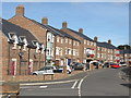
Dalton Crescent, Neville's Cross, Durham
A crescent of modern town houses, just off the former A1.
Image: © David Hawgood
Taken: 11 Sep 2016
0.08 miles
5
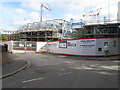
Construction of Sheraton House, student residence, Durham
Sheraton House will have 191 bedrooms. Also part of Sheraton Park is the existing Neville House, being renovated to provide 227 bedrooms. The site was part of New College of the University of Durham.
Image: © David Hawgood
Taken: 11 Sep 2016
0.10 miles
6
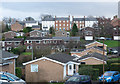
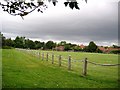
Modern housing in Durham city
Virtually all of the houses in this view from Archers' Rise are modern. The district is close to Neville's Cross and is probably part of it, lying south-west of the city centre, the cathedral and the castle.
Image: © Trevor Littlewood
Taken: 25 Jan 2016
0.12 miles
7
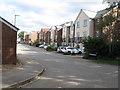
Faraday Court, off Clay Lane, Durham
A street of modern houses.
Image: © David Hawgood
Taken: 11 Sep 2016
0.12 miles
8
Ordnance Survey Cut Mark
This OS cut mark can be found on Ashville, Nevilles Cross Bank. It marks a point 88.084m above mean sea level.
Image: © Adrian Dust
Taken: 14 Sep 2018
0.15 miles
9
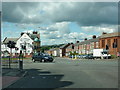
Junction of the A690 and A167
With Michelangelo's Bar and Restaurant to the left of the photo
Image: © Alexander P Kapp
Taken: 24 Jun 2011
0.15 miles
10
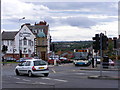
Neville's Cross Junction
The A167 at Neville's Cross Durham.
Image: © Gordon Griffiths
Taken: 28 Jun 2008
0.16 miles