IMAGES TAKEN NEAR TO
South Bailey, DURHAM, DH1 3RJ
Introduction
This page details the photographs taken nearby to South Bailey, DH1 3RJ by members of the Geograph project.
The Geograph project started in 2005 with the aim of publishing, organising and preserving representative images for every square kilometre of Great Britain, Ireland and the Isle of Man.

There are currently over 7.5m images from over14,400 individuals and you can help contribute to the project by visiting https://www.geograph.org.uk
Image Map
Images are licensed for reuse under creativecommons.org/licenses/by-sa/2.0
Notes
- Clicking on the map will re-center to the selected point.
- The higher the marker number, the further away the image location is from the centre of the postcode.
Image Listing (956 Images Found)
Images are licensed for reuse under creativecommons.org/licenses/by-sa/2.0
Image
Details
Distance
1

Ordnance Survey Cut Mark
This OS cut mark can be found on the College Gate, South Bailey. It marks a point 60.347m above mean sea level.
Image: © Adrian Dust
Taken: 15 Sep 2018
0.01 miles
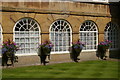
2

St John's College, Durham
Haughton House on North Bailey, the college's main building http://www.dur.ac.uk/st-johns.college
Image: © Paul Harrop
Taken: 30 Jul 2011
0.02 miles
3

"Les Voyageurs", Durham Lumiere 2011
One of a number of illuminated wire-frame sculptures created by Cedric le Borgne suspended above the South Bailey for the Durham Lumiere festival, 2011.
Image: © Oliver Dixon
Taken: 17 Nov 2011
0.02 miles
4

South Bailey, Durham
The South Bailey runs from the Cathedral to Prebends bridge across the river Wear. Today's buildings mostly date from the 17th Century and reflect a change to a prosperous residential neighborhood from the origins as part of the castle's protective earthworks (as the name bailey suggests). Most (if not all) property on South Bailey is owned by the University.
Image: © David Robinson
Taken: 19 May 2016
0.02 miles
5

Haughton House, North Bailey, Durham
An imposing facade due to the all-over use of rustication, a feature normally reserved for the ground floor alone. It was built c1730 for Sir Robert Eden (last governor of Maryland before US independence). Grade II* listed.
It is now occupied by St John's College, a college of the University of Durham.
Image: © Stephen Richards
Taken: 23 Jul 2003
0.02 miles
6

St. John's College
On South Bailey in Durham.
Image: © DS Pugh
Taken: 28 Aug 2014
0.02 miles
7
Durham: building in the Close, to the south of the Cathedral
Image: © Christopher Hilton
Taken: 16 Aug 2016
0.03 miles
8

St. John's College, Durham Lumiere 2015
Image: © Richard Cooke
Taken: 14 Nov 2015
0.03 miles
9

St.John's College, Durham University, on South Bailey
Looking north from the river bend along South Bailey, with St. John's College on the right, and the Cathedral entrance lodge on the left.
Image: © Renata Edge
Taken: Unknown
0.04 miles
10

St. John's College, Durham
St. John's College's buildings on the left, leading down towards the River Wear.
Image: © Renata Edge
Taken: Unknown
0.04 miles