IMAGES TAKEN NEAR TO
Rokeby Square, DURHAM, DH1 3QE
Introduction
This page details the photographs taken nearby to Rokeby Square, DH1 3QE by members of the Geograph project.
The Geograph project started in 2005 with the aim of publishing, organising and preserving representative images for every square kilometre of Great Britain, Ireland and the Isle of Man.

There are currently over 7.5m images from over14,400 individuals and you can help contribute to the project by visiting https://www.geograph.org.uk
Image Map
Images are licensed for reuse under creativecommons.org/licenses/by-sa/2.0
Notes
- Clicking on the map will re-center to the selected point.
- The higher the marker number, the further away the image location is from the centre of the postcode.
Image Listing (9 Images Found)
Images are licensed for reuse under creativecommons.org/licenses/by-sa/2.0
Image
Details
Distance

2
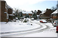
Baliol Square Durham
A very snowy scene in Durham in the winter of 2004.
Image: © Malcolm Neal
Taken: 28 Feb 2004
0.14 miles
3
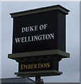
Sign for the Duke Of Wellington public house, Durham
Image: © JThomas
Taken: 28 Nov 2015
0.21 miles
4
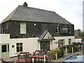
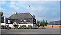
Ember Pub and Dining at The Duke of Wellington
In Darlington Road Durham City
Image: © Peter Robinson
Taken: 13 Apr 2011
0.21 miles
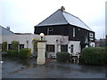
5

Duke of Wellington
Pub on the A167 at Nevilles Cross.
Image: © Gordon Griffiths
Taken: 20 Apr 2008
0.22 miles
6
The Duke Of Wellington public house, Durham
An Ember Inn on Darlington Road.
Image: © JThomas
Taken: 28 Nov 2015
0.23 miles
7
The Duke of Wellington, Darlington Road
Image: © Des Blenkinsopp
Taken: 27 Aug 2022
0.24 miles
8
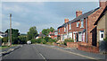
Lowe's Barn Bank, Durham
Towards the western edge of the Durham built up area.
Image: © Des Blenkinsopp
Taken: 27 Aug 2022
0.24 miles
9

Cycle lane alongside the A167 on the southern outskirts of Durham City
Image: © Peter Robinson
Taken: 1 Mar 2013
0.24 miles