IMAGES TAKEN NEAR TO
Hallgarth Street, DURHAM, DH1 3BP
Introduction
This page details the photographs taken nearby to Hallgarth Street, DH1 3BP by members of the Geograph project.
The Geograph project started in 2005 with the aim of publishing, organising and preserving representative images for every square kilometre of Great Britain, Ireland and the Isle of Man.

There are currently over 7.5m images from over14,400 individuals and you can help contribute to the project by visiting https://www.geograph.org.uk
Image Map
Images are licensed for reuse under creativecommons.org/licenses/by-sa/2.0
Notes
- Clicking on the map will re-center to the selected point.
- The higher the marker number, the further away the image location is from the centre of the postcode.
Image Listing (243 Images Found)
Images are licensed for reuse under creativecommons.org/licenses/by-sa/2.0
Image
Details
Distance
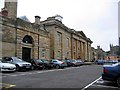
1
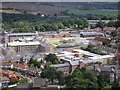
Durham Prison
Seen from the main tower of the cathedral. Both of these very different buildings are within the same kilometre square.
Image: © John Illingworth
Taken: 29 Aug 2006
0.02 miles
2
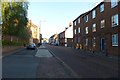
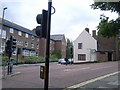
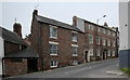
Hallgarth Street
Looking towards the Victoria pub.
Image: © DS Pugh
Taken: 28 Aug 2014
0.05 miles
3
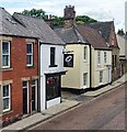
The Rabbit Hole Oriental Restaurant - Durham
Image: © Anthony Parkes
Taken: 12 Jun 2022
0.06 miles
5
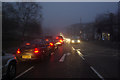
New Elvet, Durham
The light has almost gone at just before 4pm on a December afternoon as traffic pours up and down New Elvet. The photograph was taken from a pedestrian refuge.
Image: © Stephen McKay
Taken: 11 Dec 2009
0.08 miles
6
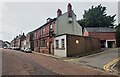
Junction of Palmer's Garth & Church Street
Image: © Nick Mutton 01329 000000
Taken: 29 Aug 2008
0.08 miles
7
Ordnance Survey 1GL Bolt
This OS Bolt can be found on the University English Department, Hallgarth Street. It marks a point 164.2ft above mean sea level.
Image: © Adrian Dust
Taken: 14 Sep 2018
0.08 miles
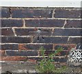
10
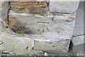
Ordnance Survey Cut Mark
This OS cut mark can be found on the wall NE side of Hallgarth Street. It marks a point 49.930m above mean sea level.
Image: © Adrian Dust
Taken: 14 Sep 2018
0.08 miles