IMAGES TAKEN NEAR TO
Damson Way, DURHAM, DH1 2YN
Introduction
This page details the photographs taken nearby to Damson Way, DH1 2YN by members of the Geograph project.
The Geograph project started in 2005 with the aim of publishing, organising and preserving representative images for every square kilometre of Great Britain, Ireland and the Isle of Man.

There are currently over 7.5m images from over14,400 individuals and you can help contribute to the project by visiting https://www.geograph.org.uk
Image Map (Loading...)


Getting Data...Please wait
Leaflet Map data © OpenStreetMap
Images are licensed for reuse under creativecommons.org/licenses/by-sa/2.0
Notes
- Clicking on the map will re-center to the selected point.
- The higher the marker number, the further away the image location is from the centre of the postcode.
Image Listing (32 Images Found)
Images are licensed for reuse under creativecommons.org/licenses/by-sa/2.0
Image
Details
Distance
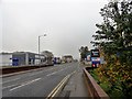
1
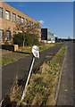
Damson Way, Durham
The no parking sign may have fallen victim to the turning lorries of which it warns.
Image: © Paul Harrop
Taken: 16 Feb 2014
0.04 miles
2
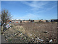
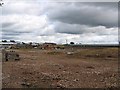
Brownfield site at Gilesgate
Gilesgate is a district of Durham, east of the city centre; the part of that district seen here is an unlovely area - a litter-scattered vacant site with industrial units and retail parks nearby.
Image: © Trevor Littlewood
Taken: 10 Mar 2014
0.09 miles
3
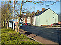
Houses on Dragon Lane
Houses on the east side of Dragon Lane in the Gilesgate district of Durham city.
Image: © Trevor Littlewood
Taken: 20 Jan 2020
0.11 miles
4
Brownfield Site awaiting development in Dragon Lane
Earmarked for retail development
Image: © Roger Smith
Taken: 4 Jul 2007
0.11 miles
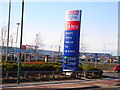
7
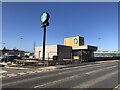
New Drive Thru Retail Unit Under Construction
Image: © David Robinson
Taken: 18 Mar 2022
0.14 miles
8
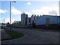
Looking down Dragon Lane
With Dragonville Industrial Estate on the left. View is looking south down to the Gilesgate Moor Hotel in the centre of the picture.
Image: © Robert Graham
Taken: 16 Oct 2018
0.15 miles
9
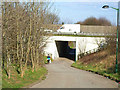
Renny's Lane, Durham, passing under A1(M)
Image: © Oliver Dixon
Taken: 10 Apr 2006
0.15 miles