IMAGES TAKEN NEAR TO
West Sherburn, DURHAM, DH1 2SB
Introduction
This page details the photographs taken nearby to DH1 2SB by members of the Geograph project.
The Geograph project started in 2005 with the aim of publishing, organising and preserving representative images for every square kilometre of Great Britain, Ireland and the Isle of Man.

There are currently over 7.5m images from over14,400 individuals and you can help contribute to the project by visiting https://www.geograph.org.uk
Image Map
Images are licensed for reuse under creativecommons.org/licenses/by-sa/2.0
Notes
- Clicking on the map will re-center to the selected point.
- The higher the marker number, the further away the image location is from the centre of the postcode.
Image Listing (15 Images Found)
Images are licensed for reuse under creativecommons.org/licenses/by-sa/2.0
Image
Details
Distance
3
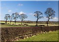
Sherburn Grange trees
Trees lining the drive to the farm, seen from the side of the adjacent B1283
Image: © Paul Harrop
Taken: 16 Feb 2014
0.12 miles
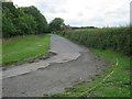
4

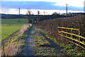
Track to Sherburn Grange
Leading to the farm from the B1283
Image: © Paul Harrop
Taken: 16 Feb 2014
0.13 miles
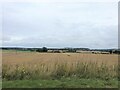
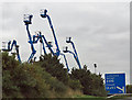
8
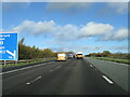
Access platforms, Durham
Some of the equipment at the Nationwide Platforms depot on Damson Way, which directly overlooks, and is prominently visible from, the A1(M).
Image: © Paul Harrop
Taken: 16 Feb 2014
0.21 miles
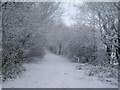
9
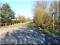
Renny's Lane, Durham
Part of National Cycle Network route 14
Image: © Oliver Dixon
Taken: 10 Apr 2006
0.21 miles
10
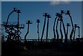
Cherry pickers
On the industrial estate off the A1M approaching junction 62.
Image: © Pauline E
Taken: 11 Oct 2013
0.21 miles