IMAGES TAKEN NEAR TO
Bedfordshire Drive, DURHAM, DH1 2LX
Introduction
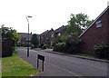
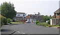
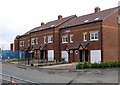
This page details the photographs taken nearby to Bedfordshire Drive, DH1 2LX by members of the Geograph project.
The Geograph project started in 2005 with the aim of publishing, organising and preserving representative images for every square kilometre of Great Britain, Ireland and the Isle of Man.

There are currently over 7.5m images from over14,400 individuals and you can help contribute to the project by visiting https://www.geograph.org.uk
Image Map
Images are licensed for reuse under creativecommons.org/licenses/by-sa/2.0
Notes
- Clicking on the map will re-center to the selected point.
- The higher the marker number, the further away the image location is from the centre of the postcode.
Image Listing (7 Images Found)
Images are licensed for reuse under creativecommons.org/licenses/by-sa/2.0
Image
Details
Distance
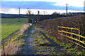
7
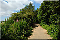
Renny's Lane
Renny's Lane lies on the south side of Belmont, an eastern district of Durham; the view is to the west, towards another part of the city - Gilesgate Moor.
Image: © Trevor Littlewood
Taken: 10 Jul 2014
0.24 miles