IMAGES TAKEN NEAR TO
Warwickshire Drive, DURHAM, DH1 2LU
Introduction
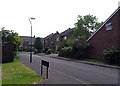
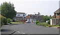
This page details the photographs taken nearby to Warwickshire Drive, DH1 2LU by members of the Geograph project.
The Geograph project started in 2005 with the aim of publishing, organising and preserving representative images for every square kilometre of Great Britain, Ireland and the Isle of Man.

There are currently over 7.5m images from over14,400 individuals and you can help contribute to the project by visiting https://www.geograph.org.uk
Image Map
Images are licensed for reuse under creativecommons.org/licenses/by-sa/2.0
Notes
- Clicking on the map will re-center to the selected point.
- The higher the marker number, the further away the image location is from the centre of the postcode.
Image Listing (8 Images Found)
Images are licensed for reuse under creativecommons.org/licenses/by-sa/2.0
Image
Details
Distance
4
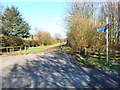
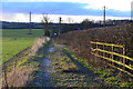
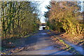
Renny's Lane, Durham
Part of National Cycle Network route 14
Image: © Oliver Dixon
Taken: 10 Apr 2006
0.19 miles
7
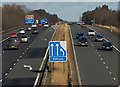
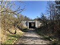
A1(M) near Durham
Looking north from the A181 bridge near Dragonville, as traffic approaches junction 62, the A690 turnoff for Durham city centre.
Image: © Paul Harrop
Taken: 16 Feb 2014
0.23 miles