IMAGES TAKEN NEAR TO
North View, DURHAM, DH1 2LE
Introduction
This page details the photographs taken nearby to North View, DH1 2LE by members of the Geograph project.
The Geograph project started in 2005 with the aim of publishing, organising and preserving representative images for every square kilometre of Great Britain, Ireland and the Isle of Man.

There are currently over 7.5m images from over14,400 individuals and you can help contribute to the project by visiting https://www.geograph.org.uk
Image Map
Images are licensed for reuse under creativecommons.org/licenses/by-sa/2.0
Notes
- Clicking on the map will re-center to the selected point.
- The higher the marker number, the further away the image location is from the centre of the postcode.
Image Listing (51 Images Found)
Images are licensed for reuse under creativecommons.org/licenses/by-sa/2.0
Image
Details
Distance
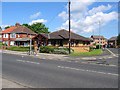
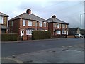
2
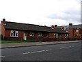
Bus stop and shelter on Sunderland Road
Looking east.
Image: © JThomas
Taken: 28 May 2015
0.05 miles
3
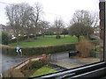
The Moorlands
A Green in the centre of a road in Gilsgate Durham.
Image: © Gordon Griffiths
Taken: 14 Jan 2006
0.08 miles
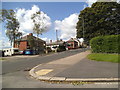
5
Bungalows standing on the site of the old Gilesgate Infant School.
Image: © Roger Smith
Taken: 4 Jul 2007
0.08 miles
6
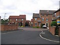
Mackintosh Court
In the 19th century Kepier Colliery stood here. In more recent times a green known as "The Duffy" occupied the site and many locals still use the name.
Image: © Roger Smith
Taken: 4 Jul 2007
0.09 miles
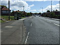
8
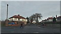
Moorlands View
The view down the A181 Sherburn Road in Durham.
Image: © Gordon Griffiths
Taken: 18 Aug 2014
0.12 miles