IMAGES TAKEN NEAR TO
Sherburn Road, DURHAM, DH1 2LA
Introduction
This page details the photographs taken nearby to Sherburn Road, DH1 2LA by members of the Geograph project.
The Geograph project started in 2005 with the aim of publishing, organising and preserving representative images for every square kilometre of Great Britain, Ireland and the Isle of Man.

There are currently over 7.5m images from over14,400 individuals and you can help contribute to the project by visiting https://www.geograph.org.uk
Image Map
Images are licensed for reuse under creativecommons.org/licenses/by-sa/2.0
Notes
- Clicking on the map will re-center to the selected point.
- The higher the marker number, the further away the image location is from the centre of the postcode.
Image Listing (36 Images Found)
Images are licensed for reuse under creativecommons.org/licenses/by-sa/2.0
Image
Details
Distance
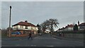
1
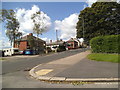
Moorlands View
The view down the A181 Sherburn Road in Durham.
Image: © Gordon Griffiths
Taken: 18 Aug 2014
0.03 miles
2
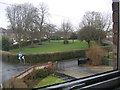
The Moorlands
A Green in the centre of a road in Gilsgate Durham.
Image: © Gordon Griffiths
Taken: 14 Jan 2006
0.07 miles
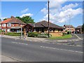
4
Bus stop and shelter on Sunderland Road
Looking east.
Image: © JThomas
Taken: 28 May 2015
0.11 miles
5
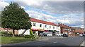
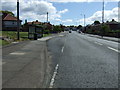
Sherburn Road
Heading eastwards out of Durham. Mixed residential and retail, with a large former cinema at the end.
Image: © Des Blenkinsopp
Taken: 21 Aug 2022
0.11 miles
6
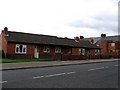
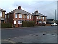
Bungalows standing on the site of the old Gilesgate Infant School.
Image: © Roger Smith
Taken: 4 Jul 2007
0.12 miles
9
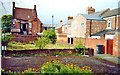
The Shows from the flats
The back of Shows pub from the flats in 2009
Image: © Malcolm Hazel
Taken: 1 Mar 2009
0.16 miles
10
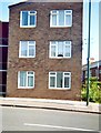
The end block and back of Sherburn Road Flats
Image: © Malcolm Hazel
Taken: 1 Mar 2009
0.16 miles