IMAGES TAKEN NEAR TO
Marshall Terrace, DURHAM, DH1 2HX
Introduction
This page details the photographs taken nearby to Marshall Terrace, DH1 2HX by members of the Geograph project.
The Geograph project started in 2005 with the aim of publishing, organising and preserving representative images for every square kilometre of Great Britain, Ireland and the Isle of Man.

There are currently over 7.5m images from over14,400 individuals and you can help contribute to the project by visiting https://www.geograph.org.uk
Image Map
Images are licensed for reuse under creativecommons.org/licenses/by-sa/2.0
Notes
- Clicking on the map will re-center to the selected point.
- The higher the marker number, the further away the image location is from the centre of the postcode.
Image Listing (34 Images Found)
Images are licensed for reuse under creativecommons.org/licenses/by-sa/2.0
Image
Details
Distance
1
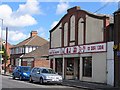
D. J. Tool Hire, formerly the Rex cinema
Opened in 1928 as The Crescent, this 320 seat cinema had its name changed to The Rex in 1942. Its final show was in 1958.
Image: © Roger Smith
Taken: 8 May 2007
0.04 miles
2
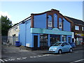
The Old Cinema Launderette
On Sunderland Road.
Image: © JThomas
Taken: 28 May 2015
0.05 miles
3
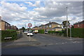
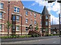
Kepier Crescent
A 20th century street with a medieval name. In the middle ages, Kepier was the site of a mill and a monastic hospital or almshouse. https://en.wikipedia.org/wiki/Kepier_Hospital
Image: © Des Blenkinsopp
Taken: 21 Aug 2022
0.12 miles
6
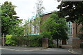
St Joseph's RC Church Durham
St Joseph's church Mill Lane Durham.
Image: © edward mcmaihin
Taken: 20 Jul 2013
0.15 miles
7
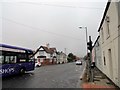
The Travellers Rest
Pub on Sunderland Road in Gilesgate Moor, at the junction with Dragon Lane. The bus is the No20 service coming into Durham from Sunderland, appropriately.
Image: © Robert Graham
Taken: 16 Oct 2018
0.15 miles
8
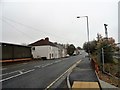
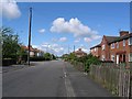
Terraced houses on Dragon Lane
These are at the north end of the street looking towards the junction with Sunderland Road. The terrace is late C19, from the time when this was just a pit village. Now part of the eastern suburbs of Durham City.
Image: © Robert Graham
Taken: 16 Oct 2018
0.15 miles
9
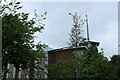
St Joseph's Church Spire Durham
The spire on the St Joseph's Church in Mill Lane.
Image: © edward mcmaihin
Taken: 20 Jul 2013
0.16 miles
10
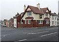
The Travellers Rest
In the village of Gilesgate Moor near Durham City.
The road to the left is Dragon Lane and that in the foreground, Sunderland Road.
Image: © Chris Tweedy
Taken: 2 Feb 2006
0.17 miles