IMAGES TAKEN NEAR TO
Fir Avenue, DURHAM, DH1 2EU
Introduction
This page details the photographs taken nearby to Fir Avenue, DH1 2EU by members of the Geograph project.
The Geograph project started in 2005 with the aim of publishing, organising and preserving representative images for every square kilometre of Great Britain, Ireland and the Isle of Man.

There are currently over 7.5m images from over14,400 individuals and you can help contribute to the project by visiting https://www.geograph.org.uk
Image Map (Loading...)


Getting Data...Please wait
Leaflet Map data © OpenStreetMap
Images are licensed for reuse under creativecommons.org/licenses/by-sa/2.0
Notes
- Clicking on the map will re-center to the selected point.
- The higher the marker number, the further away the image location is from the centre of the postcode.
Image Listing (13 Images Found)
Images are licensed for reuse under creativecommons.org/licenses/by-sa/2.0
Image
Details
Distance
1
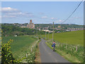
Looking back to the city
The view from near Old Durham towards the cathedral. The lane forms part of the cycle route to Sunderland and this is nearly the last (or first) view of the city.
Image: © Stephen Craven
Taken: 21 May 2007
0.17 miles
2
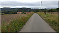
The road to Old Durham
Old Durham is a small settlement lying to the east of Durham city itself. The cathedral is the dominant building in the distant view seen here from an unfamiliar direction. The tarmacked road is presumably the vehicle route to Old Durham but has no public vehicular access; it is however a bridleway.
Image: © Trevor Littlewood
Taken: 10 Mar 2014
0.18 miles
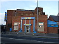
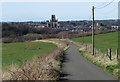
5
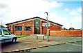
Apollo Bingo, Sherburn Road
A former cinema which then became a bingo hall called Top Ten Image before a name change to Apollo. It looks a bit closed, but hard to tell if that's temporary or permanent.
Image: © Des Blenkinsopp
Taken: 21 Aug 2022
0.20 miles
6

Side of an old Cinema
A rather empty sort of picture dominated by the brick side wall of the former Majestic Cinema.
Image: © Des Blenkinsopp
Taken: 21 Aug 2022
0.21 miles
7
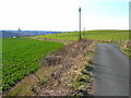
The road to Old Durham
This quiet road is part of National Cycle Network route 14 into Durham city
Image: © Clive Nicholson
Taken: 12 Aug 2016
0.21 miles
8
The road to Old Durham
Part of National Cycle Network route 14. Durham Cathedral can be seen on the skyline
Image: © Oliver Dixon
Taken: 10 Apr 2006
0.22 miles
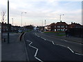
10
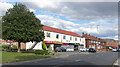
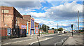
Sherburn Road
Heading eastwards out of Durham. Mixed residential and retail, with a large former cinema at the end.
Image: © Des Blenkinsopp
Taken: 21 Aug 2022
0.22 miles