IMAGES TAKEN NEAR TO
Sutherland Place, DURHAM, DH1 2EF
Introduction
This page details the photographs taken nearby to Sutherland Place, DH1 2EF by members of the Geograph project.
The Geograph project started in 2005 with the aim of publishing, organising and preserving representative images for every square kilometre of Great Britain, Ireland and the Isle of Man.

There are currently over 7.5m images from over14,400 individuals and you can help contribute to the project by visiting https://www.geograph.org.uk
Image Map
Images are licensed for reuse under creativecommons.org/licenses/by-sa/2.0
Notes
- Clicking on the map will re-center to the selected point.
- The higher the marker number, the further away the image location is from the centre of the postcode.
Image Listing (14 Images Found)
Images are licensed for reuse under creativecommons.org/licenses/by-sa/2.0
Image
Details
Distance
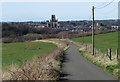
4
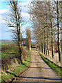
Looking back to the city
The view from near Old Durham towards the cathedral. The lane forms part of the cycle route to Sunderland and this is nearly the last (or first) view of the city.
Image: © Stephen Craven
Taken: 21 May 2007
0.18 miles
5
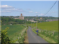
The road to Old Durham
Part of National Cycle Network route 14. Durham Cathedral can be seen on the skyline
Image: © Oliver Dixon
Taken: 10 Apr 2006
0.19 miles
6
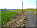
Benthouse Lane " the Trod "
Image: © GRAEME and LESLEY CRANSTON
Taken: 25 Sep 2006
0.20 miles
7
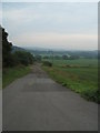
The road to Old Durham
Old Durham is a small settlement lying to the east of Durham city itself. The cathedral is the dominant building in the distant view seen here from an unfamiliar direction. The tarmacked road is presumably the vehicle route to Old Durham but has no public vehicular access; it is however a bridleway.
Image: © Trevor Littlewood
Taken: 10 Mar 2014
0.20 miles
8
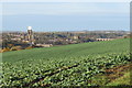
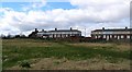
Farmland near Old Durham
Looking across farmland with the City of Durham in the background, the cathedral, castle and railway viaduct all visible.
Image: © David Robinson
Taken: 13 Nov 2016
0.20 miles