IMAGES TAKEN NEAR TO
Bent House Lane, DURHAM, DH1 2EA
Introduction
This page details the photographs taken nearby to Bent House Lane, DH1 2EA by members of the Geograph project.
The Geograph project started in 2005 with the aim of publishing, organising and preserving representative images for every square kilometre of Great Britain, Ireland and the Isle of Man.

There are currently over 7.5m images from over14,400 individuals and you can help contribute to the project by visiting https://www.geograph.org.uk
Image Map
Images are licensed for reuse under creativecommons.org/licenses/by-sa/2.0
Notes
- Clicking on the map will re-center to the selected point.
- The higher the marker number, the further away the image location is from the centre of the postcode.
Image Listing (14 Images Found)
Images are licensed for reuse under creativecommons.org/licenses/by-sa/2.0
Image
Details
Distance
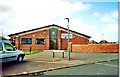
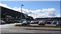
5
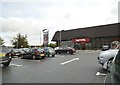
TK Maxx Durham
The view on the Dragonville Retail Park in Durham.
Image: © Gordon Griffiths
Taken: 14 Aug 2014
0.14 miles
6
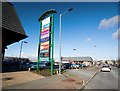
Dragon Lane, Durham
Showing the entrance to the Dragonville Retail Park which appears to offer everything the more cost-conscious shopper could desire, plus tropical fish.
Image: © Paul Harrop
Taken: 16 Feb 2014
0.15 miles
8
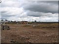
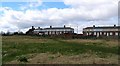
Brownfield Site awaiting development in Dragon Lane
Earmarked for retail development
Image: © Roger Smith
Taken: 4 Jul 2007
0.20 miles
9
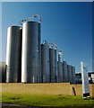
Tanks on Damson Way, Durham
Storage vessels at the Faerch Plast factory on the Dragonville Industrial Estate. It primarily makes plastic trays used for ready meals and fresh meat.
Image: © Paul Harrop
Taken: 16 Feb 2014
0.22 miles
10
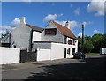
Bay Horse
This pub was formerly called "The Coal Hole"
Image: © Roger Smith
Taken: 8 May 2007
0.23 miles