IMAGES TAKEN NEAR TO
Lincolnshire Close, DURHAM, DH1 2BP
Introduction
This page details the photographs taken nearby to Lincolnshire Close, DH1 2BP by members of the Geograph project.
The Geograph project started in 2005 with the aim of publishing, organising and preserving representative images for every square kilometre of Great Britain, Ireland and the Isle of Man.

There are currently over 7.5m images from over14,400 individuals and you can help contribute to the project by visiting https://www.geograph.org.uk
Image Map (Loading...)


Getting Data...Please wait
Leaflet Map data © OpenStreetMap
Images are licensed for reuse under creativecommons.org/licenses/by-sa/2.0
Notes
- Clicking on the map will re-center to the selected point.
- The higher the marker number, the further away the image location is from the centre of the postcode.
Image Listing (31 Images Found)
Images are licensed for reuse under creativecommons.org/licenses/by-sa/2.0
Image
Details
Distance
1
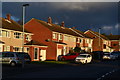
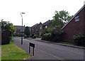
Suburban sunrise
Intense early sunlight on houses in Devonshire Road.
Image: © David Martin
Taken: 14 Feb 2016
0.07 miles
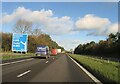
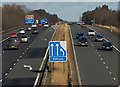
5
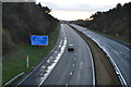
Belmont : A1(M)
Heading north on the A1(M).
Image: © Lewis Clarke
Taken: 21 Sep 2020
0.11 miles
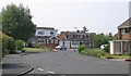
7
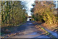
The cold road south
An icy morning view of the A1(M): first sunlight just catching the tops of the distant trees.
Image: © David Martin
Taken: 14 Feb 2016
0.15 miles
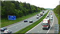
10
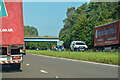
A1(M) near Durham
Looking north from the A181 bridge near Dragonville, as traffic approaches junction 62, the A690 turnoff for Durham city centre.
Image: © Paul Harrop
Taken: 16 Feb 2014
0.18 miles