IMAGES TAKEN NEAR TO
Mossdale, DURHAM, DH1 2AZ
Introduction
This page details the photographs taken nearby to Mossdale, DH1 2AZ by members of the Geograph project.
The Geograph project started in 2005 with the aim of publishing, organising and preserving representative images for every square kilometre of Great Britain, Ireland and the Isle of Man.

There are currently over 7.5m images from over14,400 individuals and you can help contribute to the project by visiting https://www.geograph.org.uk
Image Map
Images are licensed for reuse under creativecommons.org/licenses/by-sa/2.0
Notes
- Clicking on the map will re-center to the selected point.
- The higher the marker number, the further away the image location is from the centre of the postcode.
Image Listing (19 Images Found)
Images are licensed for reuse under creativecommons.org/licenses/by-sa/2.0
Image
Details
Distance
7
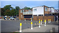
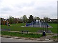
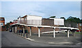
Yellow bollards round the edge
Parking area by the Cheveley Park shops.
Image: © Des Blenkinsopp
Taken: 23 Aug 2022
0.21 miles
9
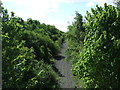
Dismantled railway, Broomside Cutting
Looking south from Broomside Lane Bridge
The former Leamside Line.
Image: © JThomas
Taken: 28 May 2015
0.21 miles
10
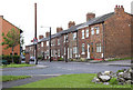
Ramp to the First Floor
Housing near the Cheveley Park shops.
Image: © Des Blenkinsopp
Taken: 23 Aug 2022
0.22 miles