IMAGES TAKEN NEAR TO
Cheveley Walk, DURHAM, DH1 2AU
Introduction
This page details the photographs taken nearby to Cheveley Walk, DH1 2AU by members of the Geograph project.
The Geograph project started in 2005 with the aim of publishing, organising and preserving representative images for every square kilometre of Great Britain, Ireland and the Isle of Man.

There are currently over 7.5m images from over14,400 individuals and you can help contribute to the project by visiting https://www.geograph.org.uk
Image Map
Images are licensed for reuse under creativecommons.org/licenses/by-sa/2.0
Notes
- Clicking on the map will re-center to the selected point.
- The higher the marker number, the further away the image location is from the centre of the postcode.
Image Listing (9 Images Found)
Images are licensed for reuse under creativecommons.org/licenses/by-sa/2.0
Image
Details
Distance
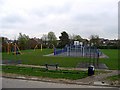

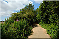
5
Renny's Lane Bridleway
Paved bridleway running along the southern edge of Belmont.
Image: © David Robinson
Taken: 18 Mar 2022
0.22 miles
6
Renny's Lane
Renny's Lane lies on the south side of Belmont, an eastern district of Durham; the view is to the west, towards another part of the city - Gilesgate Moor.
Image: © Trevor Littlewood
Taken: 10 Jul 2014
0.23 miles
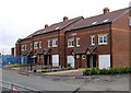
7
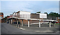
Ramp to the First Floor
Housing near the Cheveley Park shops.
Image: © Des Blenkinsopp
Taken: 23 Aug 2022
0.23 miles
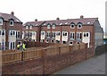
8
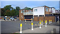
Yellow bollards round the edge
Parking area by the Cheveley Park shops.
Image: © Des Blenkinsopp
Taken: 23 Aug 2022
0.23 miles
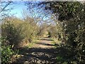
9
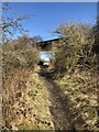
Two Disused Railway Lines
Going under - The Durham -Sunderland Railway, gave Durham its first station at Shincliffe in the 1830s, remained rope hauled until around 1860s serving early collieries, branch to Durham Elvet built 1890s but passenger trains lasted only until 1931, the line closing West of Murton Colliery in 1953.
Going over - the Leamside line, the original route of the ECML before Tursdale - Durham - Newcastle was opened. Lost its passenger services in 1960s, hung on as a lightly used freight route and occasional diversionary route, especially for weekend engineering and during remodelling / electrification of the ECML. Closed early 1990s.
Image: © David Robinson
Taken: 18 Mar 2022
0.25 miles