IMAGES TAKEN NEAR TO
Belmont, DURHAM, DH1 1SS
Introduction
This page details the photographs taken nearby to DH1 1SS by members of the Geograph project.
The Geograph project started in 2005 with the aim of publishing, organising and preserving representative images for every square kilometre of Great Britain, Ireland and the Isle of Man.

There are currently over 7.5m images from over14,400 individuals and you can help contribute to the project by visiting https://www.geograph.org.uk
Image Map
Images are licensed for reuse under creativecommons.org/licenses/by-sa/2.0
Notes
- Clicking on the map will re-center to the selected point.
- The higher the marker number, the further away the image location is from the centre of the postcode.
Image Listing (4 Images Found)
Images are licensed for reuse under creativecommons.org/licenses/by-sa/2.0
Image
Details
Distance
1
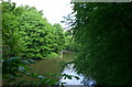
Kepier Wood & Belmont Viaduct
A view of the River Wear through Kepier Wood, looking towards Belmont Viaduct. Built in 1856 by the North Eastern Railway, the disused railway viaduct is grade II listed and stands 130ft high.
Image: © David Robinson
Taken: 18 May 2006
0.17 miles
2
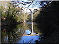
Belmont Viaduct
Disused Viaduct over Wear River.
Image: © anna
Taken: 19 Feb 2012
0.17 miles
3
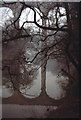
Disused Railway Viaduct over the River Wear
This railway carried a line from Durham towards Sunderland
Image: © John Thorn
Taken: Unknown
0.20 miles
4
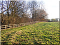
Wooden fence alongside wooded gorge
The fence bounds a surprisingly deep stream groove which bars easy access from a path - a right of way - leaving Kepier Wood, to another right of way, downstream along the River Wear.
Image: © Trevor Littlewood
Taken: 24 Nov 2017
0.25 miles