IMAGES TAKEN NEAR TO
Claypath, DURHAM, DH1 1SA
Introduction
This page details the photographs taken nearby to Claypath, DH1 1SA by members of the Geograph project.
The Geograph project started in 2005 with the aim of publishing, organising and preserving representative images for every square kilometre of Great Britain, Ireland and the Isle of Man.

There are currently over 7.5m images from over14,400 individuals and you can help contribute to the project by visiting https://www.geograph.org.uk
Image Map
Images are licensed for reuse under creativecommons.org/licenses/by-sa/2.0
Notes
- Clicking on the map will re-center to the selected point.
- The higher the marker number, the further away the image location is from the centre of the postcode.
Image Listing (730 Images Found)
Images are licensed for reuse under creativecommons.org/licenses/by-sa/2.0
Image
Details
Distance
1
Ordnance Survey Cut Mark
This OS cut mark can be found on the west face of the Chapel on Claypath. It marks a point 49.030m above mean sea level.
Image: © Adrian Dust
Taken: 14 Sep 2018
0.04 miles
2
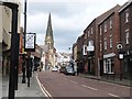
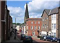
The curiously named street called Claypath, City of Durham
With the tall spire of Christchurch dominating the scene
Image: © Derek Voller
Taken: 17 May 2015
0.04 miles
3
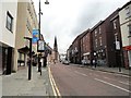
Gilesgate, Durham
Leading down to the city centre and the River Wear
Image: © Tim Heaton
Taken: 16 May 2023
0.04 miles
5
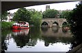
Old Elvet Bridge
A stone bridge of ten arches, built during the time of Hugh Pudsey (Prince Bishop of Durham, 1154-1198). See http://en.wikipedia.org/wiki/Hugh_de_Puiset
Image: © Roger Smith
Taken: 25 Jul 2007
0.04 miles
6
Traffic Lights: junction of Claypath and Providence Row
Image: © Roger Smith
Taken: 4 Jun 2008
0.05 miles
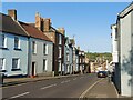
8
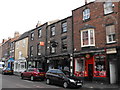
Looking east along Claypath
Viewed from near the west end of the street, which runs from the bottom of the marketplace in Durham City. This is one of the old medieval streets, although most of the buildings here are more recent. The church spire is Christchurch, formerly the United Reformed Church of 1886.
Image: © Robert Graham
Taken: 12 Jul 2019
0.05 miles
9
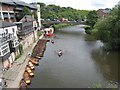
River Wear from Elvet Bridge, Durham
Because of the double bend in the river, this view upstream is actually looking north-east. The new main road bridge can be seen in the distance, with the back of the Prince Bishop shopping centre on the left.
Image: © Oliver Dixon
Taken: 14 Jul 2007
0.06 miles
10
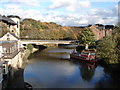
New Elvet Bridge
Taken from the Old Elvet Bridge on a crisp autumn day.
Image: © Trevor Rickard
Taken: 8 Nov 2006
0.06 miles