IMAGES TAKEN NEAR TO
Claypath, DURHAM, DH1 1RP
Introduction
This page details the photographs taken nearby to Claypath, DH1 1RP by members of the Geograph project.
The Geograph project started in 2005 with the aim of publishing, organising and preserving representative images for every square kilometre of Great Britain, Ireland and the Isle of Man.

There are currently over 7.5m images from over14,400 individuals and you can help contribute to the project by visiting https://www.geograph.org.uk
Image Map
Images are licensed for reuse under creativecommons.org/licenses/by-sa/2.0
Notes
- Clicking on the map will re-center to the selected point.
- The higher the marker number, the further away the image location is from the centre of the postcode.
Image Listing (514 Images Found)
Images are licensed for reuse under creativecommons.org/licenses/by-sa/2.0
Image
Details
Distance
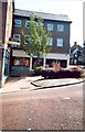
2
Traffic Lights: junction of Claypath and Providence Row
Image: © Roger Smith
Taken: 4 Jun 2008
0.02 miles
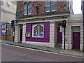
4
Claypath Court apartments
Until recent years this was the main post office for Durham.
Image: © Roger Smith
Taken: 4 Jun 2008
0.02 miles
5
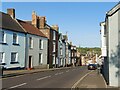
Gilesgate, Durham
Leading down to the city centre and the River Wear
Image: © Tim Heaton
Taken: 16 May 2023
0.03 miles
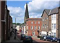
6
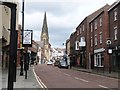
The curiously named street called Claypath, City of Durham
With the tall spire of Christchurch dominating the scene
Image: © Derek Voller
Taken: 17 May 2015
0.03 miles
7
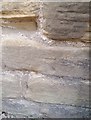
Ordnance Survey Cut Mark
This OS cut mark can be found on the west face of the Chapel on Claypath. It marks a point 49.030m above mean sea level.
Image: © Adrian Dust
Taken: 14 Sep 2018
0.05 miles
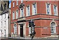
9
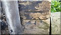
Ordnance Survey Cut Mark
This OS cut mark can be found on No1 Leazes Place. It marks a point 61.222m above mean sea level.
Image: © Adrian Dust
Taken: 14 Sep 2018
0.07 miles
10
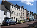
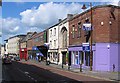
Houses towards the top of Claypath
The third house from the left has a City of Durham Trust blue plaque indicating that James Finlay Weir Johnston, applied scientist and scholar, lived here. From his bequest Durham Johnston School was founded
Image: © Roger Smith
Taken: 4 Jun 2008
0.07 miles