IMAGES TAKEN NEAR TO
Gilesgate, DURHAM, DH1 1QN
Introduction
This page details the photographs taken nearby to Gilesgate, DH1 1QN by members of the Geograph project.
The Geograph project started in 2005 with the aim of publishing, organising and preserving representative images for every square kilometre of Great Britain, Ireland and the Isle of Man.

There are currently over 7.5m images from over14,400 individuals and you can help contribute to the project by visiting https://www.geograph.org.uk
Image Map
Images are licensed for reuse under creativecommons.org/licenses/by-sa/2.0
Notes
- Clicking on the map will re-center to the selected point.
- The higher the marker number, the further away the image location is from the centre of the postcode.
Image Listing (126 Images Found)
Images are licensed for reuse under creativecommons.org/licenses/by-sa/2.0
Image
Details
Distance
1
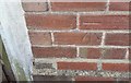
Ordnance Survey Cut Mark
This OS cut mark can be found on the NE angle of the block of flats on Gilesgate. It marks a point 70.216m above mean sea level.
Image: © Adrian Dust
Taken: 14 Sep 2018
0.03 miles
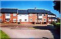
4
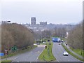
Leazes Road
The view from Gilesgate Durham towards the Cathedral.
Image: © Gordon Griffiths
Taken: 8 Mar 2014
0.05 miles
5
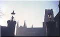
Gateposts, Durham Castle, 1968
Looking between the entrance gateposts out across Palace Green to the cathedral. The gateway is described thus: "2 octagonal piers with frieze and battlemented coping; wrought iron scrolls on top support square gas lamps" http://list.english-heritage.org.uk/resultsingle.aspx?uid=1322867&searchtype=mapsearch , and probably dates from 1790 when the gatehouse was altered.
Image: © Derek Harper
Taken: Unknown
0.05 miles
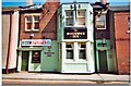
7

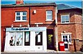
Wedding Limo Leaves the College
Outside St Hild & St Bede's College.
Image: © Des Blenkinsopp
Taken: 30 Mar 2012
0.06 miles
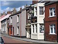
9
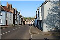
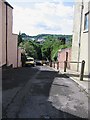
Gilesgate, Durham
Shortly becomes Claypath, as the road descends towards the centre of Durham and the River Wear
Image: © Chris Heaton
Taken: 16 May 2023
0.06 miles