IMAGES TAKEN NEAR TO
St. Hilds Lane, DURHAM, DH1 1QL
Introduction
This page details the photographs taken nearby to St. Hilds Lane, DH1 1QL by members of the Geograph project.
The Geograph project started in 2005 with the aim of publishing, organising and preserving representative images for every square kilometre of Great Britain, Ireland and the Isle of Man.

There are currently over 7.5m images from over14,400 individuals and you can help contribute to the project by visiting https://www.geograph.org.uk
Image Map
Images are licensed for reuse under creativecommons.org/licenses/by-sa/2.0
Notes
- Clicking on the map will re-center to the selected point.
- The higher the marker number, the further away the image location is from the centre of the postcode.
Image Listing (141 Images Found)
Images are licensed for reuse under creativecommons.org/licenses/by-sa/2.0
Image
Details
Distance
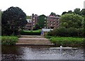
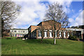
1
Bede College: some of the original buildings
Image: © Roger Smith
Taken: 4 Jun 2008
0.03 miles
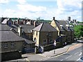
5
St Hild & St Bede College Buildings
Image: © Des Blenkinsopp
Taken: 30 Mar 2012
0.07 miles
6
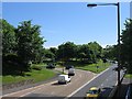
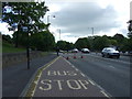
Durham Dawn
View of Durham on entry by the A690 road.
Image: © Gordon Griffiths
Taken: 11 May 2006
0.07 miles
7
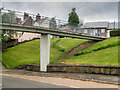
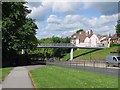
Footbridge to Gilesgate
Bridge giving pedestrians a safer way to cross the busy A690 dual carriageway.
Image: © David Dixon
Taken: 21 May 2021
0.07 miles
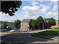
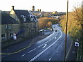
8
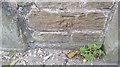
Ordnance Survey Cut Mark
This OS cut mark can be found on the wall at the junction of Pelaw Leazes Lane. It marks a point 60.457m above mean sea level.
Image: © Adrian Dust
Taken: 14 Sep 2018
0.07 miles