IMAGES TAKEN NEAR TO
Wilson Crescent, DURHAM, DH1 1PF
Introduction
This page details the photographs taken nearby to Wilson Crescent, DH1 1PF by members of the Geograph project.
The Geograph project started in 2005 with the aim of publishing, organising and preserving representative images for every square kilometre of Great Britain, Ireland and the Isle of Man.

There are currently over 7.5m images from over14,400 individuals and you can help contribute to the project by visiting https://www.geograph.org.uk
Image Map
Images are licensed for reuse under creativecommons.org/licenses/by-sa/2.0
Notes
- Clicking on the map will re-center to the selected point.
- The higher the marker number, the further away the image location is from the centre of the postcode.
Image Listing (25 Images Found)
Images are licensed for reuse under creativecommons.org/licenses/by-sa/2.0
Image
Details
Distance
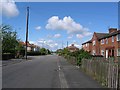
1
Kepier Crescent
A 20th century street with a medieval name. In the middle ages, Kepier was the site of a mill and a monastic hospital or almshouse. https://en.wikipedia.org/wiki/Kepier_Hospital
Image: © Des Blenkinsopp
Taken: 21 Aug 2022
0.07 miles
2
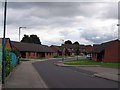
Whitwell Court: Aged Miners Association Bungalows
Image: © Roger Smith
Taken: 4 Jul 2007
0.09 miles
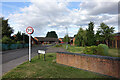
3
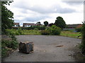
Brownfield Site awaiting development
Until recently the Infant department of Gilesgate Primary School stood on this site but this has now moved across the lane to join the Junior department.
Image: © Roger Smith
Taken: 4 Jul 2007
0.10 miles
5
Whitwell Court
A street of low rise housing administered by the Durham Aged Mineworkers Homes Association.
Image: © Des Blenkinsopp
Taken: 21 Aug 2022
0.11 miles
6
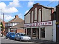
D. J. Tool Hire, formerly the Rex cinema
Opened in 1928 as The Crescent, this 320 seat cinema had its name changed to The Rex in 1942. Its final show was in 1958.
Image: © Roger Smith
Taken: 8 May 2007
0.12 miles
7
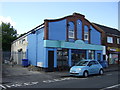
The Old Cinema Launderette
On Sunderland Road.
Image: © JThomas
Taken: 28 May 2015
0.13 miles
8
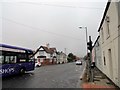
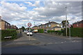
The Travellers Rest
Pub on Sunderland Road in Gilesgate Moor, at the junction with Dragon Lane. The bus is the No20 service coming into Durham from Sunderland, appropriately.
Image: © Robert Graham
Taken: 16 Oct 2018
0.15 miles
9

Part of Musgrave Gardens
One of several adjoining roads with that name forming a triangle of housing on the north side of Sunderland Road.
Image: © Des Blenkinsopp
Taken: 21 Aug 2022
0.16 miles