IMAGES TAKEN NEAR TO
Wantage Road, DURHAM, DH1 1LR
Introduction
This page details the photographs taken nearby to Wantage Road, DH1 1LR by members of the Geograph project.
The Geograph project started in 2005 with the aim of publishing, organising and preserving representative images for every square kilometre of Great Britain, Ireland and the Isle of Man.

There are currently over 7.5m images from over14,400 individuals and you can help contribute to the project by visiting https://www.geograph.org.uk
Image Map
Images are licensed for reuse under creativecommons.org/licenses/by-sa/2.0
Notes
- Clicking on the map will re-center to the selected point.
- The higher the marker number, the further away the image location is from the centre of the postcode.
Image Listing (18 Images Found)
Images are licensed for reuse under creativecommons.org/licenses/by-sa/2.0
Image
Details
Distance
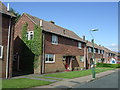
1
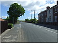
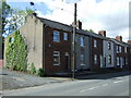
Wantage Road (nos 60 - 84)
The Wantage Road address continued along a short cul de sac off Wantage Road itself.
Image: © Des Blenkinsopp
Taken: 23 Aug 2022
0.06 miles
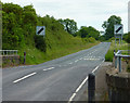
3
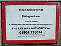
Sign on railway bridge FEP/32
On Pittington Lane, Carrville.
The railway has now been taken up.
Image: © JThomas
Taken: 28 May 2015
0.12 miles
7
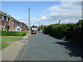
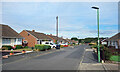
Bainbridge Street, Carrville
Looking north west.
Image: © JThomas
Taken: 28 May 2015
0.13 miles
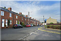
10
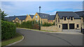
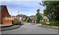
New Housing, Ramside Park
A recent development on the eastern edge of suburban Durham.
Image: © Des Blenkinsopp
Taken: 23 Aug 2022
0.14 miles