IMAGES TAKEN NEAR TO
Mayorswell Field, DURHAM, DH1 1JW
Introduction
This page details the photographs taken nearby to Mayorswell Field, DH1 1JW by members of the Geograph project.
The Geograph project started in 2005 with the aim of publishing, organising and preserving representative images for every square kilometre of Great Britain, Ireland and the Isle of Man.

There are currently over 7.5m images from over14,400 individuals and you can help contribute to the project by visiting https://www.geograph.org.uk
Image Map
Images are licensed for reuse under creativecommons.org/licenses/by-sa/2.0
Notes
- Clicking on the map will re-center to the selected point.
- The higher the marker number, the further away the image location is from the centre of the postcode.
Image Listing (73 Images Found)
Images are licensed for reuse under creativecommons.org/licenses/by-sa/2.0
Image
Details
Distance
1
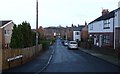
Mayorswell Field
All quiet on Christmas Day.
Image: © Russel Wills
Taken: 25 Dec 2018
0.03 miles
2
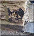
Ordnance Survey Cut Mark
This OS cut mark can be found on No18 Ellis Leazes Street. It marks a point 59.323m above mean sea level.
Image: © Adrian Dust
Taken: 14 Sep 2018
0.04 miles
4
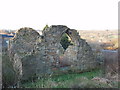
Chapel of hospital of St Mary Magdalene, Durham
The chapel, now in ruins, was built in 1451. History, Topography and Directory of Durham, Whellan, London, 1894, quoted by Genuki http://www.joinermarriageindex.com/pjoiner/genuki/DUR/DurhamCity/index.html , tells us:
"The ruined chapel of St. Mary Magdalen stands on the north side of Gilesgate, near to the old railway station. This was the chapel of the Hospital of St. Mary Magdalen, which stood near it, and included in-brethren and out-brethren and also sisters. It has not been used for services since the Restoration, though there have been interments in the cemetery, which has now been closed for many years."
Image: © David Hawgood
Taken: 23 Dec 2005
0.07 miles

10

Gateposts, Durham Castle, 1968
Looking between the entrance gateposts out across Palace Green to the cathedral. The gateway is described thus: "2 octagonal piers with frieze and battlemented coping; wrought iron scrolls on top support square gas lamps" http://list.english-heritage.org.uk/resultsingle.aspx?uid=1322867&searchtype=mapsearch , and probably dates from 1790 when the gatehouse was altered.
Image: © Derek Harper
Taken: Unknown
0.09 miles