IMAGES TAKEN NEAR TO
Wakenshaw Road, DURHAM, DH1 1EW
Introduction
This page details the photographs taken nearby to Wakenshaw Road, DH1 1EW by members of the Geograph project.
The Geograph project started in 2005 with the aim of publishing, organising and preserving representative images for every square kilometre of Great Britain, Ireland and the Isle of Man.

There are currently over 7.5m images from over14,400 individuals and you can help contribute to the project by visiting https://www.geograph.org.uk
Image Map
Images are licensed for reuse under creativecommons.org/licenses/by-sa/2.0
Notes
- Clicking on the map will re-center to the selected point.
- The higher the marker number, the further away the image location is from the centre of the postcode.
Image Listing (62 Images Found)
Images are licensed for reuse under creativecommons.org/licenses/by-sa/2.0
Image
Details
Distance
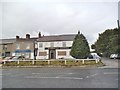
2
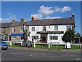
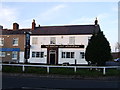
Durham Light Infantryman public house
The horse isn't coming out of the pub. It just happens to be passing.
Image: © Roger Smith
Taken: 4 Jun 2008
0.09 miles
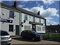
4
Durham Light
The view of the closed pub The Durham Light Infantryman in Gilesgate, Durham.
Image: © Gordon Griffiths
Taken: 14 Aug 2014
0.10 miles
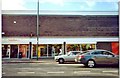
6
The Durham Light Infantryman, Gilesgate
Currently boarded up.
See Image for when it was still open.
Image: © JThomas
Taken: 28 May 2015
0.11 miles
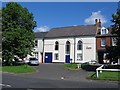
7
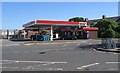
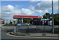
Sainsbury's, Sunderland Road, Gilsgate, Durham
Image: © Malcolm Hazel
Taken: 1 Mar 2009
0.11 miles
9
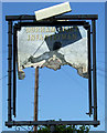
Remains of the sign for the Durham Light Infantryman, Gilesgate
Image: © JThomas
Taken: 28 May 2015
0.11 miles