IMAGES TAKEN NEAR TO
Hawthorn Crescent, DURHAM, DH1 1ED
Introduction
This page details the photographs taken nearby to Hawthorn Crescent, DH1 1ED by members of the Geograph project.
The Geograph project started in 2005 with the aim of publishing, organising and preserving representative images for every square kilometre of Great Britain, Ireland and the Isle of Man.

There are currently over 7.5m images from over14,400 individuals and you can help contribute to the project by visiting https://www.geograph.org.uk
Image Map
Images are licensed for reuse under creativecommons.org/licenses/by-sa/2.0
Notes
- Clicking on the map will re-center to the selected point.
- The higher the marker number, the further away the image location is from the centre of the postcode.
Image Listing (24 Images Found)
Images are licensed for reuse under creativecommons.org/licenses/by-sa/2.0
Image
Details
Distance
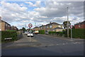
1
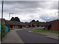
Whitwell Court: Aged Miners Association Bungalows
Image: © Roger Smith
Taken: 4 Jul 2007
0.08 miles
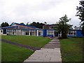
2
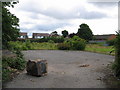
Brownfield Site awaiting development
Until recently the Infant department of Gilesgate Primary School stood on this site but this has now moved across the lane to join the Junior department.
Image: © Roger Smith
Taken: 4 Jul 2007
0.09 miles
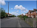
3
Whitwell Court
A street of low rise housing administered by the Durham Aged Mineworkers Homes Association.
Image: © Des Blenkinsopp
Taken: 21 Aug 2022
0.12 miles
4
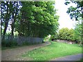
Footpath adjacent to Gilesgate Primary School
The wooden fence on the right is the boundary of High Grange Estate. High Grange Farm stood on the right of the track where it bends to the left. It, and a medieval tithe barn alongside, were demolished about 1960 and the farmland was sold to builder William Leech for a reputed £17,000. High Grange Estate was completed in the late 1960's.
Image: © Roger Smith
Taken: 8 May 2007
0.12 miles
5
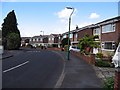
Kepier Crescent
A 20th century street with a medieval name. In the middle ages, Kepier was the site of a mill and a monastic hospital or almshouse. https://en.wikipedia.org/wiki/Kepier_Hospital
Image: © Des Blenkinsopp
Taken: 21 Aug 2022
0.12 miles
8
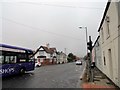
The Travellers Rest
Pub on Sunderland Road in Gilesgate Moor, at the junction with Dragon Lane. The bus is the No20 service coming into Durham from Sunderland, appropriately.
Image: © Robert Graham
Taken: 16 Oct 2018
0.18 miles
10
High Grange Estate: Rowan Tree Avenue
The estate was built during the second half of the 1969's. This particular street, Rowan Tree Avenue, was completed in 1967.
Image: © Roger Smith
Taken: 8 May 2007
0.18 miles