IMAGES TAKEN NEAR TO
The Willows, DURHAM, DH1 1BP
Introduction
This page details the photographs taken nearby to The Willows, DH1 1BP by members of the Geograph project.
The Geograph project started in 2005 with the aim of publishing, organising and preserving representative images for every square kilometre of Great Britain, Ireland and the Isle of Man.

There are currently over 7.5m images from over14,400 individuals and you can help contribute to the project by visiting https://www.geograph.org.uk
Image Map (Loading...)


Getting Data...Please wait
Leaflet Map data © OpenStreetMap
Images are licensed for reuse under creativecommons.org/licenses/by-sa/2.0
Notes
- Clicking on the map will re-center to the selected point.
- The higher the marker number, the further away the image location is from the centre of the postcode.
Image Listing (17 Images Found)
Images are licensed for reuse under creativecommons.org/licenses/by-sa/2.0
Image
Details
Distance
1
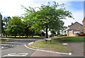
High Street, Carrville
At the junction with Dene Drive.
Image: © Des Blenkinsopp
Taken: 23 Aug 2022
0.08 miles
2
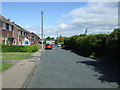
Bainbridge Street, Carrville
Looking north west.
Image: © JThomas
Taken: 28 May 2015
0.09 miles
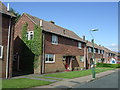
3
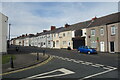
Terraced Houses, Carrville High Street
Image: © Des Blenkinsopp
Taken: 23 Aug 2022
0.10 miles
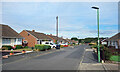
7
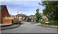
Wantage Road (nos 60 - 84)
The Wantage Road address continued along a short cul de sac off Wantage Road itself.
Image: © Des Blenkinsopp
Taken: 23 Aug 2022
0.18 miles
8
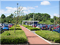
Planted beds at Belmont Park and Ride
Durham has three park and ride termini. Belmont and Sniperley are connected by a single route passing through the city centre; the other terminus, Howlands, has a service only to and from the city.
The beds are planted with low-maintenance species.
Image: © Trevor Littlewood
Taken: 7 Jun 2017
0.22 miles
9
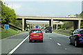
A1(M) at the Carrville Interchange
Carrville Interchange is junction 62 of the A1(M) where it intersects with the A680, serving Durham (to the west) and Sunderland (to the east).
Image: © David Dixon
Taken: 29 Apr 2019
0.22 miles
10
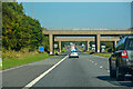
Belmont : A1(M)
Heading north on the A1(M).
Image: © Lewis Clarke
Taken: 21 Sep 2020
0.23 miles