IMAGES TAKEN NEAR TO
Swinside Drive, DURHAM, DH1 1AE
Introduction
This page details the photographs taken nearby to Swinside Drive, DH1 1AE by members of the Geograph project.
The Geograph project started in 2005 with the aim of publishing, organising and preserving representative images for every square kilometre of Great Britain, Ireland and the Isle of Man.

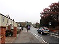
There are currently over 7.5m images from over14,400 individuals and you can help contribute to the project by visiting https://www.geograph.org.uk
Image Map (Loading...)


Getting Data...Please wait
Leaflet Map data © OpenStreetMap
Images are licensed for reuse under creativecommons.org/licenses/by-sa/2.0
Notes
- Clicking on the map will re-center to the selected point.
- The higher the marker number, the further away the image location is from the centre of the postcode.
Image Listing (39 Images Found)
Images are licensed for reuse under creativecommons.org/licenses/by-sa/2.0
Image
Details
Distance
1
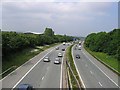
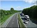
A1M motorway looking north towards the Carville junction
Image: © Roger Smith
Taken: 8 Jun 2007
0.03 miles
2
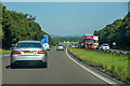
Belmont : A1(M)
Heading north on the A1(M).
Image: © Lewis Clarke
Taken: 21 Sep 2020
0.04 miles
5
Bus on Carrville High Street
This is view north at the south end of the street at the junction with Broomside Lane. The bus is the Go Northeast No 20 service from Durham to Sunderland and then on to South Shields. This is a good service, with a bus every 10 minutes.
Image: © Robert Graham
Taken: 16 Oct 2018
0.08 miles
6
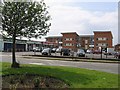
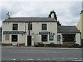
Blue House Shops, Carville High Street
The apartment block at the far side of the car park is nearing completion.
Image: © Roger Smith
Taken: 8 Jun 2007
0.08 miles
7
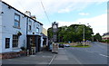
The Belmont on Brookside Lane in Durham
Image: © Mat Fascione
Taken: 24 Jun 2017
0.09 miles
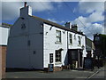
10
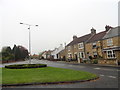
Moor End, Belmont
This is the site of the original village in Victorian times. Moor End Cottages are shown on the first Ordnance Survey map of 1861.
Image: © Robert Graham
Taken: 16 Oct 2018
0.09 miles