IMAGES TAKEN NEAR TO
Port Logan, STRANRAER, DG9 9NW
Introduction
This page details the photographs taken nearby to DG9 9NW by members of the Geograph project.
The Geograph project started in 2005 with the aim of publishing, organising and preserving representative images for every square kilometre of Great Britain, Ireland and the Isle of Man.

There are currently over 7.5m images from over14,400 individuals and you can help contribute to the project by visiting https://www.geograph.org.uk
Image Map
Images are licensed for reuse under creativecommons.org/licenses/by-sa/2.0
Notes
- Clicking on the map will re-center to the selected point.
- The higher the marker number, the further away the image location is from the centre of the postcode.
Image Listing (6 Images Found)
Images are licensed for reuse under creativecommons.org/licenses/by-sa/2.0
Image
Details
Distance
1
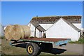
Trailer & farm buildings at Garrochtrie
Image: © Leslie Barrie
Taken: 18 Apr 2015
0.04 miles
3
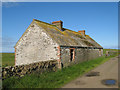
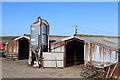
Empty cottages
Empty cottages at the side of the farm track from Garrochtrie. Many fewer people work on the land today, with its mechanised farming.
Image: © Jonathan Wilkins
Taken: 8 Aug 2012
0.09 miles
4
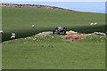
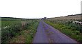
Farmland at Garrochtrie
This was viewed from the B7065.
Image: © Walter Baxter
Taken: 23 May 2013
0.21 miles