IMAGES TAKEN NEAR TO
Ardwell, STRANRAER, DG9 9LU
Introduction
This page details the photographs taken nearby to DG9 9LU by members of the Geograph project.
The Geograph project started in 2005 with the aim of publishing, organising and preserving representative images for every square kilometre of Great Britain, Ireland and the Isle of Man.

There are currently over 7.5m images from over14,400 individuals and you can help contribute to the project by visiting https://www.geograph.org.uk
Image Map
Images are licensed for reuse under creativecommons.org/licenses/by-sa/2.0
Notes
- Clicking on the map will re-center to the selected point.
- The higher the marker number, the further away the image location is from the centre of the postcode.
Image Listing (32 Images Found)
Images are licensed for reuse under creativecommons.org/licenses/by-sa/2.0
Image
Details
Distance
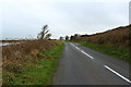
6
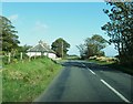
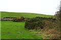
Mull of Galloway Trail at Drumantrae Bay
Heading for Ardwell.
Image: © Billy McCrorie
Taken: 31 Oct 2014
0.04 miles
7
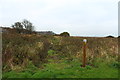
Mull of Galloway Trail near Clay Hill
Heading for Sandhead, with marker post.
Image: © Billy McCrorie
Taken: 31 Oct 2014
0.04 miles
8
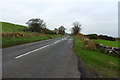
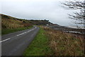
The A716 to Stranraer near Clay Hill
Image: © Billy McCrorie
Taken: 31 Oct 2014
0.04 miles
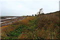
10
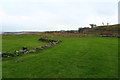
Mull of Galloway Trail near Drumantrae Bay
Heading for Ardwell.
Image: © Billy McCrorie
Taken: 31 Oct 2014
0.05 miles