IMAGES TAKEN NEAR TO
Drummore, STRANRAER, DG9 9HJ
Introduction
This page details the photographs taken nearby to DG9 9HJ by members of the Geograph project.
The Geograph project started in 2005 with the aim of publishing, organising and preserving representative images for every square kilometre of Great Britain, Ireland and the Isle of Man.

There are currently over 7.5m images from over14,400 individuals and you can help contribute to the project by visiting https://www.geograph.org.uk
Image Map
Images are licensed for reuse under creativecommons.org/licenses/by-sa/2.0
Notes
- Clicking on the map will re-center to the selected point.
- The higher the marker number, the further away the image location is from the centre of the postcode.
Image Listing (6 Images Found)
Images are licensed for reuse under creativecommons.org/licenses/by-sa/2.0
Image
Details
Distance
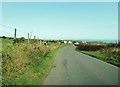
2
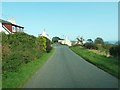
Road to Drummore
From near Damnaglaur.
Image: © Billy McCrorie
Taken: 8 Jun 2012
0.10 miles
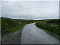
3
Damnaglaur
Road from Inshanks descendingto Damnaglaur - a priceless name.
Image: © Richard Webb
Taken: 27 Apr 2019
0.10 miles
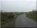
4
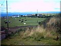
Damnaglaur
Damnaglaur is a hamlet about a mile above the village of Drummore. The Galloway Hills are visible across Luce Bay.
Image: © Jeff Wells
Taken: 12 Aug 2006
0.21 miles
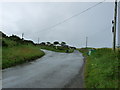
5
Road junction at Damnaglaur
The B7041 runs to the right and straight ahead is the start of the B7065.
Image: © Ann Cook
Taken: 15 Sep 2011
0.23 miles