IMAGES TAKEN NEAR TO
Main Street, STRANRAER, DG9 9AW
Introduction
This page details the photographs taken nearby to Main Street, DG9 9AW by members of the Geograph project.
The Geograph project started in 2005 with the aim of publishing, organising and preserving representative images for every square kilometre of Great Britain, Ireland and the Isle of Man.

There are currently over 7.5m images from over14,400 individuals and you can help contribute to the project by visiting https://www.geograph.org.uk
Image Map
Images are licensed for reuse under creativecommons.org/licenses/by-sa/2.0
Notes
- Clicking on the map will re-center to the selected point.
- The higher the marker number, the further away the image location is from the centre of the postcode.
Image Listing (32 Images Found)
Images are licensed for reuse under creativecommons.org/licenses/by-sa/2.0
Image
Details
Distance

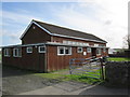
2

Garden shed at B7077 road junction, Lochans
Image: © Leslie Barrie
Taken: 16 Jun 2014
0.02 miles
3
Lochans
Bridge over the Piltanton Burn.
Image: © Billy McCrorie
Taken: 5 Mar 2012
0.02 miles
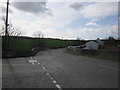
4
Lochans
Junction of the A77 with the B7077.
Image: © Billy McCrorie
Taken: 5 Mar 2012
0.02 miles
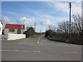
5
Bridge over the Piltanton Burn
The road immediately after the bridge is the B7077.
Image: © Ann Cook
Taken: 23 Sep 2010
0.03 miles
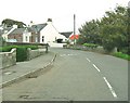
6
Main Street, Lochans
Also the A77 to Portpatrick.
Image: © Billy McCrorie
Taken: 18 Jul 2020
0.05 miles
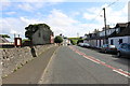
7
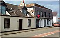
The Lochans Inn
The inn is recognised by its red "T" sign, indicating availability of Tennent's beers.
Image: © Mary and Angus Hogg
Taken: 9 Mar 2010
0.05 miles

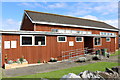
10
Lochans Village Hall
Just off Main Street opposite Lochans Lodge.
Image: © Billy McCrorie
Taken: 5 Mar 2012
0.07 miles