IMAGES TAKEN NEAR TO
Millfield Road, STRANRAER, DG9 8UB
Introduction
This page details the photographs taken nearby to Millfield Road, DG9 8UB by members of the Geograph project.
The Geograph project started in 2005 with the aim of publishing, organising and preserving representative images for every square kilometre of Great Britain, Ireland and the Isle of Man.

There are currently over 7.5m images from over14,400 individuals and you can help contribute to the project by visiting https://www.geograph.org.uk
Image Map
Images are licensed for reuse under creativecommons.org/licenses/by-sa/2.0
Notes
- Clicking on the map will re-center to the selected point.
- The higher the marker number, the further away the image location is from the centre of the postcode.
Image Listing (153 Images Found)
Images are licensed for reuse under creativecommons.org/licenses/by-sa/2.0
Image
Details
Distance
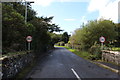
1
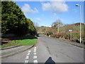
Heugh Road
From the junction with Heugh Rise.
Image: © Billy McCrorie
Taken: 5 Mar 2012
0.07 miles
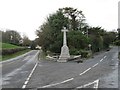
2
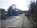
Heugh Road
Leading to Portpatrick hotel.
Image: © Billy McCrorie
Taken: 5 Mar 2012
0.07 miles
4
Heugh Road
Approaching the junction with the Stranraer road.
Image: © Billy McCrorie
Taken: 5 Mar 2012
0.08 miles
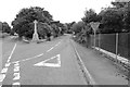
7
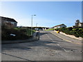
Heugh Rise
From the junction with Heugh Road.
Image: © Billy McCrorie
Taken: 5 Mar 2012
0.09 miles
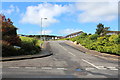
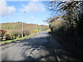
10
Heugh Road, Portpatrick
Approaching the A77.
Image: © Billy McCrorie
Taken: 21 Sep 2017
0.09 miles