IMAGES TAKEN NEAR TO
Golf Course Road, STRANRAER, DG9 8TB
Introduction
This page details the photographs taken nearby to Golf Course Road, DG9 8TB by members of the Geograph project.
The Geograph project started in 2005 with the aim of publishing, organising and preserving representative images for every square kilometre of Great Britain, Ireland and the Isle of Man.

There are currently over 7.5m images from over14,400 individuals and you can help contribute to the project by visiting https://www.geograph.org.uk
Image Map
Images are licensed for reuse under creativecommons.org/licenses/by-sa/2.0
Notes
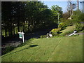
- Clicking on the map will re-center to the selected point.
- The higher the marker number, the further away the image location is from the centre of the postcode.
Image Listing (424 Images Found)
Images are licensed for reuse under creativecommons.org/licenses/by-sa/2.0
Image
Details
Distance
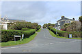
1
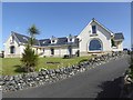
Semi-detached dormer bungalows
Off Golf Course Road.
Image: © Oliver Dixon
Taken: 2 Jul 2019
0.02 miles
2
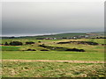
Dunskey golf course and clubhouse at Portpatrick
A lovely 18 hole golf course with some magnificent sea views at Portpatrick.
Image: © Colin McDonald
Taken: 20 Dec 2005
0.02 miles
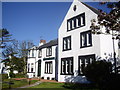
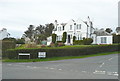
4
Front garden, Dunskey Guest House
Haugh Road, Portpatrick.
Image: © Stanley Howe
Taken: 29 May 2013
0.06 miles
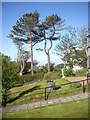
5
Terraced lawn, Dunskey Guest House
On Heugh Road, Portpatrick.
Image: © Stanley Howe
Taken: 29 May 2013
0.06 miles
9
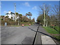
Heugh Road
From the Braefild Road junction.
Image: © Billy McCrorie
Taken: 5 Mar 2012
0.07 miles
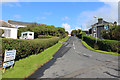
10
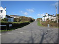
Golf Course Road
From the junction with Heugh Road.
Image: © Billy McCrorie
Taken: 5 Mar 2012
0.07 miles