IMAGES TAKEN NEAR TO
STRANRAER, DG9 8QW
Introduction
This page details the photographs taken nearby to DG9 8QW by members of the Geograph project.
The Geograph project started in 2005 with the aim of publishing, organising and preserving representative images for every square kilometre of Great Britain, Ireland and the Isle of Man.

There are currently over 7.5m images from over14,400 individuals and you can help contribute to the project by visiting https://www.geograph.org.uk
Image Map
Images are licensed for reuse under creativecommons.org/licenses/by-sa/2.0
Notes
- Clicking on the map will re-center to the selected point.
- The higher the marker number, the further away the image location is from the centre of the postcode.
Image Listing (13 Images Found)
Images are licensed for reuse under creativecommons.org/licenses/by-sa/2.0
Image
Details
Distance
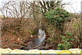
5
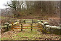
Footbridge over the Messan Burn
Looks like unsafe footbridge.
Image: © Billy McCrorie
Taken: 11 Feb 2015
0.22 miles
10
Granite Bridge at Bank of Balker
Now classed as unsafe.
Image: © Billy McCrorie
Taken: 11 Feb 2015
0.24 miles