IMAGES TAKEN NEAR TO
Lochans, STRANRAER, DG9 8NZ
Introduction
This page details the photographs taken nearby to DG9 8NZ by members of the Geograph project.
The Geograph project started in 2005 with the aim of publishing, organising and preserving representative images for every square kilometre of Great Britain, Ireland and the Isle of Man.

There are currently over 7.5m images from over14,400 individuals and you can help contribute to the project by visiting https://www.geograph.org.uk
Image Map
Images are licensed for reuse under creativecommons.org/licenses/by-sa/2.0
Notes
- Clicking on the map will re-center to the selected point.
- The higher the marker number, the further away the image location is from the centre of the postcode.
Image Listing (4 Images Found)
Images are licensed for reuse under creativecommons.org/licenses/by-sa/2.0
Image
Details
Distance
1
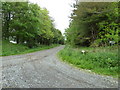
Low Boreland
Entrance track to Low Boreland Farm.
Image: © Andy Farrington
Taken: 26 May 2011
0.10 miles
2
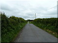
Low Boreland
View along this small country road that runs past the access road to Low Boreland Farm.
Image: © Andy Farrington
Taken: 26 May 2011
0.11 miles
3
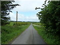
Low Boreland
View along this small country road that leads down to the A75 in Castle Kennedy.
Image: © Andy Farrington
Taken: 26 May 2011
0.12 miles
4
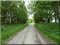
Low Boreland
View along this country road in the direction of Bridgebank and the A716.
Image: © Andy Farrington
Taken: 26 May 2011
0.13 miles