IMAGES TAKEN NEAR TO
Lochans, STRANRAER, DG9 8NN
Introduction
This page details the photographs taken nearby to DG9 8NN by members of the Geograph project.
The Geograph project started in 2005 with the aim of publishing, organising and preserving representative images for every square kilometre of Great Britain, Ireland and the Isle of Man.

There are currently over 7.5m images from over14,400 individuals and you can help contribute to the project by visiting https://www.geograph.org.uk
Image Map
Images are licensed for reuse under creativecommons.org/licenses/by-sa/2.0
Notes
- Clicking on the map will re-center to the selected point.
- The higher the marker number, the further away the image location is from the centre of the postcode.
Image Listing (19 Images Found)
Images are licensed for reuse under creativecommons.org/licenses/by-sa/2.0
Image
Details
Distance
1
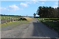
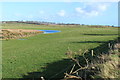
Road to Culgrange approaching Broom Park Plantation
Image: © Billy McCrorie
Taken: 7 Mar 2014
0.02 miles
2
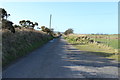
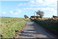
Road to Stranraer near Little Lochans
Image: © Billy McCrorie
Taken: 7 Mar 2014
0.03 miles
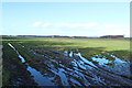
4
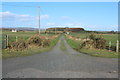
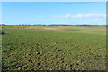
Farmland near Little Lochans
Trees on the left are part of Broom Park Plantation.
Image: © Billy McCrorie
Taken: 7 Mar 2014
0.06 miles
8
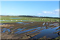
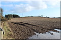
Farmland with Sheep near Lochans Moor
Image: © Billy McCrorie
Taken: 7 Mar 2014
0.08 miles
10

Two brands of alien yellow
Near Lochans. At least oilseed rape, with its noxious fumes, is useful. Gorse may look attractive in bloom, but is a major problem in Galloway and has invaded much farmland.
Image: © Oliver Dixon
Taken: 30 Apr 2006
0.12 miles