IMAGES TAKEN NEAR TO
STRANRAER, DG9 8JB
Introduction
This page details the photographs taken nearby to DG9 8JB by members of the Geograph project.
The Geograph project started in 2005 with the aim of publishing, organising and preserving representative images for every square kilometre of Great Britain, Ireland and the Isle of Man.

There are currently over 7.5m images from over14,400 individuals and you can help contribute to the project by visiting https://www.geograph.org.uk
Image Map
Images are licensed for reuse under creativecommons.org/licenses/by-sa/2.0
Notes
- Clicking on the map will re-center to the selected point.
- The higher the marker number, the further away the image location is from the centre of the postcode.
Image Listing (6 Images Found)
Images are licensed for reuse under creativecommons.org/licenses/by-sa/2.0
Image
Details
Distance
2
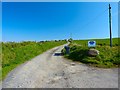
Mid Knockglass
Entrance drive to the farm.
Image: © Andy Farrington
Taken: 20 May 2012
0.12 miles
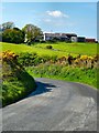
3
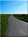
Road across the Moors
This small country road leads across the moors between Stranraer and Portpatrick cutting out the need to go via Lochans, seen here in the direction of Portpatrick.
Image: © Andy Farrington
Taken: 20 May 2012
0.13 miles
4
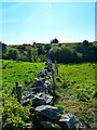
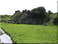
Boundary Wall
Looking towards White Hill.
Image: © Andy Farrington
Taken: 20 May 2012
0.18 miles
5
Mid Knockglass
View to Crailloch from the road to Stranraer.
Image: © Andy Farrington
Taken: 20 May 2012
0.21 miles