IMAGES TAKEN NEAR TO
Ochtrelure Way, STRANRAER, DG9 7SQ
Introduction
This page details the photographs taken nearby to Ochtrelure Way, DG9 7SQ by members of the Geograph project.
The Geograph project started in 2005 with the aim of publishing, organising and preserving representative images for every square kilometre of Great Britain, Ireland and the Isle of Man.

There are currently over 7.5m images from over14,400 individuals and you can help contribute to the project by visiting https://www.geograph.org.uk
Image Map
Images are licensed for reuse under creativecommons.org/licenses/by-sa/2.0
Notes
- Clicking on the map will re-center to the selected point.
- The higher the marker number, the further away the image location is from the centre of the postcode.
Image Listing (57 Images Found)
Images are licensed for reuse under creativecommons.org/licenses/by-sa/2.0
Image
Details
Distance
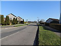
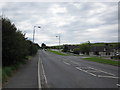
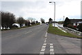
3
Ochtrelure Way, Stranraer
Looking down Ochtrelure Way from its junction with Stoneykirk Road.
Image: © Graham Robson
Taken: 23 Jun 2019
0.02 miles
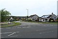
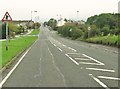
5
Stoneykirk Road
Stoneykirk Rd with junction of Ochtrelure way on the right.
Image: © Billy McCrorie
Taken: 25 Jul 2011
0.03 miles
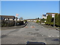
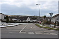
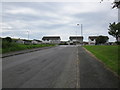
7
Commerce Road
Another entrance to Commerce Rd from Stoneykirk Rd.
Image: © Billy McCrorie
Taken: 25 Jul 2011
0.04 miles
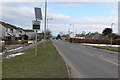
8
30 mph on Stoneykirk Road
The road on the left is Ochtrelure Way.
Image: © Ann Cook
Taken: 23 Sep 2010
0.04 miles
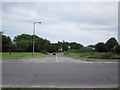
10
Commerce Road
Commerce Rd up to the junction with Stoneykirk Rd.
Image: © Billy McCrorie
Taken: 25 Jul 2011
0.05 miles