IMAGES TAKEN NEAR TO
Waverley Place, STRANRAER, DG9 7DN
Introduction
This page details the photographs taken nearby to Waverley Place, DG9 7DN by members of the Geograph project.
The Geograph project started in 2005 with the aim of publishing, organising and preserving representative images for every square kilometre of Great Britain, Ireland and the Isle of Man.

There are currently over 7.5m images from over14,400 individuals and you can help contribute to the project by visiting https://www.geograph.org.uk
Image Map
Images are licensed for reuse under creativecommons.org/licenses/by-sa/2.0
Notes
- Clicking on the map will re-center to the selected point.
- The higher the marker number, the further away the image location is from the centre of the postcode.
Image Listing (704 Images Found)
Images are licensed for reuse under creativecommons.org/licenses/by-sa/2.0
Image
Details
Distance

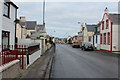
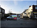
6
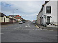
Edinburgh Road
Taken from the junction with Dalrymple Street.
Image: © Billy McCrorie
Taken: 25 Jul 2011
0.03 miles
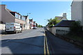
7
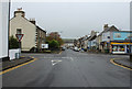
Edinburgh Road Junction with Dalrymple Street
Image: © Billy McCrorie
Taken: 14 Oct 2017
0.03 miles
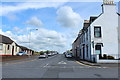
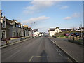
9
Edinburgh Road, Stranraer
Leading to London Road. Viewed from Dalrymple Street
Image: © Billy McCrorie
Taken: 20 Apr 2021
0.04 miles
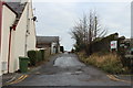
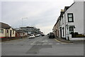
10
Academy Street
From the junction with Dalrymple Street. Academy Street leads to Lewis Street which is being re-surfaced.
Image: © Billy McCrorie
Taken: 22 Jan 2012
0.04 miles