IMAGES TAKEN NEAR TO
Belmont Crescent, STRANRAER, DG9 7BW
Introduction
This page details the photographs taken nearby to Belmont Crescent, DG9 7BW by members of the Geograph project.
The Geograph project started in 2005 with the aim of publishing, organising and preserving representative images for every square kilometre of Great Britain, Ireland and the Isle of Man.

There are currently over 7.5m images from over14,400 individuals and you can help contribute to the project by visiting https://www.geograph.org.uk
Image Map
Images are licensed for reuse under creativecommons.org/licenses/by-sa/2.0
Notes
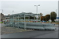
- Clicking on the map will re-center to the selected point.
- The higher the marker number, the further away the image location is from the centre of the postcode.
Image Listing (208 Images Found)
Images are licensed for reuse under creativecommons.org/licenses/by-sa/2.0
Image
Details
Distance
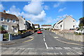
5
Belmont Road, Stranraer
Post-war development
Image: © Oliver Dixon
Taken: 30 Apr 2006
0.07 miles
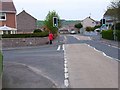
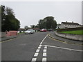
6
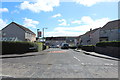
Belmont Crescent
From the junction with Belmont Road.
Image: © Billy McCrorie
Taken: 18 Mar 2012
0.09 miles
7
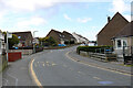
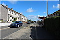
Belmont Road, Stranraer
Leading to Coronation Drive.
Image: © Billy McCrorie
Taken: 1 May 2021
0.11 miles
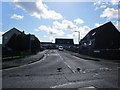
8
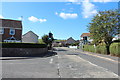
Fairhurst Road, Stranraer
From the junction with Mount Vernon Road.
Image: © Billy McCrorie
Taken: 21 Sep 2013
0.12 miles
9
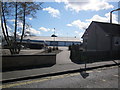
Belmont Road
Path from Belmont Road to Lidl Supermarket.
Image: © Billy McCrorie
Taken: 18 Mar 2012
0.13 miles