IMAGES TAKEN NEAR TO
Kirkcolm, STRANRAER, DG9 0RF
Introduction
This page details the photographs taken nearby to DG9 0RF by members of the Geograph project.
The Geograph project started in 2005 with the aim of publishing, organising and preserving representative images for every square kilometre of Great Britain, Ireland and the Isle of Man.

There are currently over 7.5m images from over14,400 individuals and you can help contribute to the project by visiting https://www.geograph.org.uk
Image Map
Images are licensed for reuse under creativecommons.org/licenses/by-sa/2.0
Notes
- Clicking on the map will re-center to the selected point.
- The higher the marker number, the further away the image location is from the centre of the postcode.
Image Listing (3 Images Found)
Images are licensed for reuse under creativecommons.org/licenses/by-sa/2.0
Image
Details
Distance
1
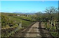
A February Farm Road
Most of the farm roads were muddy during my mid-February visits. They were drying out after a few days of sunshine and drying winds.
Image: © Mary and Angus Hogg
Taken: 12 Feb 2010
0.08 miles
2
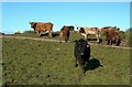
Cattle Enjoying The February Sunshine
The sunny weather was also helping to dry out the ground, which had become very soft.
Image: © Mary and Angus Hogg
Taken: 12 Feb 2010
0.16 miles
3
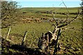
A Marshy Pool
This small pool looks like one of many kettle lakes in this area, produced during the final stages of the last Ice Age.
Image: © Mary and Angus Hogg
Taken: 12 Feb 2010
0.17 miles