IMAGES TAKEN NEAR TO
Kirkcolm, STRANRAER, DG9 0PS
Introduction
This page details the photographs taken nearby to DG9 0PS by members of the Geograph project.
The Geograph project started in 2005 with the aim of publishing, organising and preserving representative images for every square kilometre of Great Britain, Ireland and the Isle of Man.

There are currently over 7.5m images from over14,400 individuals and you can help contribute to the project by visiting https://www.geograph.org.uk
Image Map
Images are licensed for reuse under creativecommons.org/licenses/by-sa/2.0
Notes
- Clicking on the map will re-center to the selected point.
- The higher the marker number, the further away the image location is from the centre of the postcode.
Image Listing (68 Images Found)
Images are licensed for reuse under creativecommons.org/licenses/by-sa/2.0
Image
Details
Distance
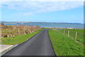
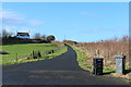
2
Approaching Low Salchrie
With view of Loch Ryan.
Image: © Billy McCrorie
Taken: 12 Apr 2014
0.05 miles
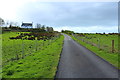
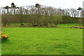
3
Farmland & Woodland at Low Salchrie
On the left is Loch Ryan.
Image: © Billy McCrorie
Taken: 12 Apr 2014
0.06 miles
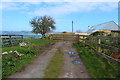
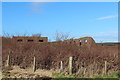
5
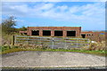
World War 2 Building at Low Salchrie
Image: © Billy McCrorie
Taken: 12 Apr 2014
0.08 miles
7
Old RAF Wig Bay Site
What's left of the Flying Boat Workshops.
Image: © Billy McCrorie
Taken: 16 Feb 2017
0.08 miles
8
Old RAF Wig Bay Site
What's left of the Flying Boat Workshops.
Image: © Billy McCrorie
Taken: 16 Feb 2017
0.08 miles
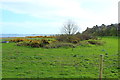
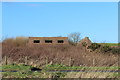
9
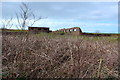
Old World War 2 Building near Low Salchrie
Image: © Billy McCrorie
Taken: 12 Apr 2014
0.08 miles