IMAGES TAKEN NEAR TO
Leswalt, STRANRAER, DG9 0PL
Introduction
This page details the photographs taken nearby to DG9 0PL by members of the Geograph project.
The Geograph project started in 2005 with the aim of publishing, organising and preserving representative images for every square kilometre of Great Britain, Ireland and the Isle of Man.

There are currently over 7.5m images from over14,400 individuals and you can help contribute to the project by visiting https://www.geograph.org.uk
Image Map
Images are licensed for reuse under creativecommons.org/licenses/by-sa/2.0
Notes
- Clicking on the map will re-center to the selected point.
- The higher the marker number, the further away the image location is from the centre of the postcode.
Image Listing (15 Images Found)
Images are licensed for reuse under creativecommons.org/licenses/by-sa/2.0
Image
Details
Distance
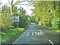
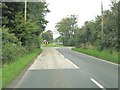
3
Roundabout near Leswalt
B798 in the foreground. The A718 from Kirkcolm comes in from the left and turns left at the roundabout towards Stranraer.
Image: © Oliver Dixon
Taken: 30 Apr 2006
0.05 miles
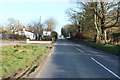
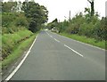
5
Roundabout on the A718
The A718 bears right at the roundabout. The B798 is straight ahead and a minor road is to the left.
Image: © Ann Cook
Taken: 23 Sep 2010
0.06 miles
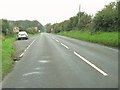
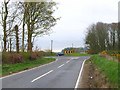
9
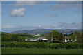
Farmland near Craigencross
Loch Ryan can be seen in the far distance
Image: © Leslie Barrie
Taken: 12 May 2012
0.13 miles
