IMAGES TAKEN NEAR TO
Church Road, STRANRAER, DG9 0NW
Introduction
This page details the photographs taken nearby to Church Road, DG9 0NW by members of the Geograph project.
The Geograph project started in 2005 with the aim of publishing, organising and preserving representative images for every square kilometre of Great Britain, Ireland and the Isle of Man.

There are currently over 7.5m images from over14,400 individuals and you can help contribute to the project by visiting https://www.geograph.org.uk
Image Map
Images are licensed for reuse under creativecommons.org/licenses/by-sa/2.0
Notes
- Clicking on the map will re-center to the selected point.
- The higher the marker number, the further away the image location is from the centre of the postcode.
Image Listing (198 Images Found)
Images are licensed for reuse under creativecommons.org/licenses/by-sa/2.0
Image
Details
Distance
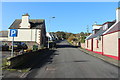
1
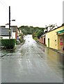
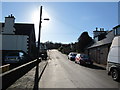
Minor road, Kirkcolm
The Post Office is on the right and the car park is on the left. The road climbs uphill to the church and cemetery.
Image: © Ann Cook
Taken: 29 Sep 2009
0.01 miles
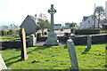
2
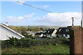
Kirkcolm Village
Viewed from the Church Graveyard.
Image: © Billy McCrorie
Taken: 21 Oct 2021
0.01 miles
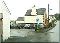
4
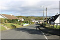
Church Road, Kirkcolm
Leading to Main Street (A718), viewed from the junction with Bayview Terrace.
Image: © Billy McCrorie
Taken: 21 Oct 2021
0.02 miles
5
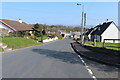
Church Road
Takes you up pass Loch Connell.
Image: © Billy McCrorie
Taken: 18 Mar 2012
0.02 miles
8
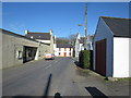
Church Road
In the direction of Main Street.
Image: © Billy McCrorie
Taken: 18 Mar 2012
0.04 miles
10

Bus Shelter, Kirkcolm
At Bayview Terrace just off Church Road.
Image: © Billy McCrorie
Taken: 21 Oct 2021
0.04 miles